Delicias geodata
Delicias (Aragon) is a section of populated place; located in Spain in Europe/Madrid (GMT+2) time zone. With population of 110,520 people, there are 82 cities with bigger population in this country. Compared to other cities in Spain, 64.8% of cities are located further ↓South; 77.9% of cities are located further ←West and 79.5% of cities have higher elevation than Delicias. Note1


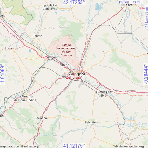
Delicias GPS coordinates[2]
41° 38' 57.408" North, 0° 54' 27.252" West
| Map corner | latitude | longitude |
|---|---|---|
| Upper-left | 42.17253°, | -1.61069° |
| Center: | 41.64928°, | -0.90757° |
| Lower-right: | 41.12175°, | -0.20444° |
| Map W x H: | 116.8×116.8 km | = 72.6×72.6mi |
| max Lat: | 43.74134° ⇑35.2% North |
| Delicias: | 41.64928° |
| min Lat: | ⇓64.8% South 27.64134° |
| min Long | Delicias | max Long |
| -18.00367° | -0.90757° | 4.2899° |
| W 77.9%⇐ | ⇒22.1% E |
Elevation
Elevation of Delicias is 228 m = 748 ft, and this is 370 m = 1214 ft below average elevation for this country.
| Max E: |
1682 m = 5518 ft | 79.5% |
| Avg. | 598 m = 1962 ft | |
| Delicias | 228 m = 748 ft | |
Min E: |
0 m = 0 ft | 20.5% |
See also: Delicias elevation on elevation.city.
Geographical zone
Delicias is located in North temperate zone (between Tropic of Cancer and the Arctic Circle). Distance of this Northern Tropic circle is 2025 km =1258.3 mi to South.| Distance of | km | miles | from Delicias |
|---|---|---|---|
| North Pole | 5376.1 | 3340.6 | to North |
| Arctic Circle | 2770.2 | 1721.3 | to North |
| Tropic Cancer | 2025 | 1258.3 | to South |
| Equator | 4631 | 2877.6 | to South |


Nearby cities:
15 places around Delicias: (largest is in red/bold)
• Alfajarín
17.4 km =10.8 mi,  103°
103°
• Almozara
1.4 km =0.9 mi,  20°
20°
• Cadrete
11.3 km =7 mi,  202°
202°
• Cuarte de Huerva
6.4 km =4 mi, 198°
• El Burgo de Ebro
16.3 km =10.1 mi,  122°
122°
• María de Huerva
14.3 km =8.9 mi,  210°
210°
• Montecanal
3.4 km =2.1 mi,  229°
229°
• Oliver-Valdefierro
2.2 km =1.4 mi,  256°
256°
• Puebla de Alfindén
13.1 km =8.1 mi, 98°
• Sobradiel
14.7 km =9.1 mi,  312°
312°
• Torres de Berrellén
17.8 km =11.1 mi, 312°
• Utebo
10 km =6.2 mi, 310°
• Villamayor de Gállego
11.9 km =7.4 mi,  70°
70°
• Villanueva de Gállego
15 km =9.3 mi,  27°
27°
• Zaragoza
2.6 km =1.6 mi, 73°
Sources, notices
• [Note1] Compared only with cities in Spain existing in our database
• [Src1] Map data: © OpenStreetMap contributors (CC-BY-SA)
• [Src2] Other city data from geonames.org with taken over terms of usage.
• [Src3] Geographical zone / Annual Mean Temperature by Robert A. Rohde @ Wikipedia
