Aranjuez geodata
Aranjuez (Madrid) is a seat of a third-order administrative division; located in Spain in Europe/Madrid (GMT+2) time zone. With population of 54,055 people, there are 172 cities with bigger population in this country. Compared to other cities in Spain, 69.9% of cities are located further ↑North; 53.7% of cities are located further →East and 61.3% of cities have higher elevation than Aranjuez. Note1


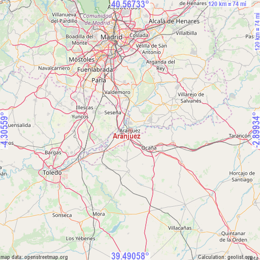
Aranjuez GPS coordinates[2]
40° 1' 51.888" North, 3° 36' 8.856" West
| Map corner | latitude | longitude |
|---|---|---|
| Upper-left | 40.56733°, | -4.30559° |
| Center: | 40.03108°, | -3.60246° |
| Lower-right: | 39.49058°, | -2.89934° |
| Map W x H: | 119.7×119.7 km | = 74.4×74.4mi |
| max Lat: | 43.74134° ⇑69.9% North |
| Aranjuez: | 40.03108° |
| min Lat: | ⇓30.1% South 27.64134° |
| min Long | Aranjuez | max Long |
| -18.00367° | -3.60246° | 4.2899° |
| W 46.3%⇐ | ⇒53.7% E |
Elevation
Elevation of Aranjuez is 508 m = 1667 ft, and this is 90 m = 295 ft below average elevation for this country.
| Max E: |
1682 m = 5518 ft | 61.3% |
| Avg. | 598 m = 1962 ft | |
| Aranjuez | 508 m = 1667 ft | |
Min E: |
0 m = 0 ft | 38.7% |
See also: Aranjuez elevation on elevation.city.
Geographical zone
Aranjuez is located in North temperate zone (between Tropic of Cancer and the Arctic Circle). Distance of this Northern Tropic circle is 1845.1 km =1146.5 mi to South.| Distance of | km | miles | from Aranjuez |
|---|---|---|---|
| North Pole | 5556 | 3452.3 | to North |
| Arctic Circle | 2950.1 | 1833.1 | to North |
| Tropic Cancer | 1845.1 | 1146.5 | to South |
| Equator | 4451 | 2765.7 | to South |


Nearby cities:
15 places around Aranjuez: (largest is in red/bold)
• Añover de Tajo
14.7 km =9.1 mi,  251°
251°
• Borox
12.2 km =7.6 mi,  289°
289°
• Cabañas de Yepes
16.7 km =10.4 mi,  159°
159°
• Ciempozuelos
14.3 km =8.9 mi,  353°
353°
• Ciruelos
10.3 km =6.4 mi,  185°
185°
• Esquivias
16.2 km =10.1 mi,  300°
300°
• Huerta de Valdecarábanos
18.7 km =11.6 mi,  182°
182°
• La Alameda de la Sagra
16.3 km =10.1 mi,  262°
262°
• Noblejas
14.9 km =9.3 mi,  112°
112°
• Ocaña
12 km =7.5 mi,  132°
132°
• Ontígola
3.9 km =2.4 mi,  139°
139°
• Seseña
11.5 km =7.1 mi,  315°
315°
• Titulcia
12 km =7.5 mi,  14°
14°
• Villaconejos
12.9 km =8 mi,  52°
52°
• Yepes
14.5 km =9 mi, 187°
Sources, notices
• [Note1] Compared only with cities in Spain existing in our database
• [Src1] Map data: © OpenStreetMap contributors (CC-BY-SA)
• [Src2] Other city data from geonames.org with taken over terms of usage.
• [Src3] Geographical zone / Annual Mean Temperature by Robert A. Rohde @ Wikipedia
