Serradilla del Arroyo geodata
Serradilla del Arroyo (Castille and León) is a seat of a third-order administrative division; located in Spain in Europe/Madrid (GMT+2) time zone. With population of 387 people, there are 4176 cities with bigger population in this country. Compared to other cities in Spain, 61.4% of cities are located further ↑North; 90% of cities are located further →East and 75.4% of cities have lower elevation than Serradilla del Arroyo. Note1
Administrative division(s):
- Level 1: Castille and León
- Level 2: Provincia de Salamanca
- Level 3: Serradilla del Arroyo
Current local time in Serradilla del Arroyo:
11:57 PM, ThursdayDifference from your time zone: hours


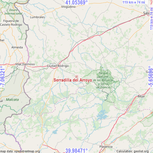
Serradilla del Arroyo GPS coordinates[2]
40° 31' 16.788" North, 6° 21' 36.288" West
| Map corner | latitude | longitude |
|---|---|---|
| Upper-left | 41.05369°, | -7.06321° |
| Center: | 40.52133°, | -6.36008° |
| Lower-right: | 39.98471°, | -5.65696° |
| Map W x H: | 118.9×118.9 km | = 73.9×73.9mi |
| max Lat: | 43.74134° ⇑61.4% North |
| Serradilla del Arroyo: | 40.52133° |
| min Lat: | ⇓38.6% South 27.64134° |
| min Long | Serradilla del | max Long |
| -18.00367° | -6.36008° | 4.2899° |
| W 10%⇐ | ⇒90% E |
Elevation
Elevation of Serradilla del Arroyo is 855 m = 2805 ft, and this is 257 m = 843 ft above average elevation for this country.
| Max E: |
1682 m = 5518 ft | 24.6% |
| Serradilla del Arroyo | 855 m 2805 ft | |
| Avg. | 598 m = 1962 ft | |
Min E: |
0 m = 0 ft | 75.4% |
See also: Spain elevation on elevation.city.
Geographical zone
Serradilla del Arroyo is located in North temperate zone (between Tropic of Cancer and the Arctic Circle). Distance of this Northern Tropic circle is 1899.6 km =1180.4 mi to South.| Distance of | km | miles | from Serradilla del Arroyo |
|---|---|---|---|
| North Pole | 5501.5 | 3418.5 | to North |
| Arctic Circle | 2895.6 | 1799.2 | to North |
| Tropic Cancer | 1899.6 | 1180.4 | to South |
| Equator | 4505.5 | 2799.6 | to South |


Nearby cities:
15 places around Serradilla del Arroyo: (largest is in red/bold)
• Agallas
10.6 km =6.6 mi,  220°
220°
• Alba de Yeltes
17.1 km =10.6 mi,  12°
12°
• Casares de las Hurdes
11.7 km =7.3 mi,  146°
146°
• Ciudad Rodrigo
17 km =10.6 mi,  300°
300°
• Dios le Guarde
14 km =8.7 mi,  15°
15°
• Herguijuela de Ciudad Rodrigo
15.3 km =9.5 mi,  242°
242°
• Ladrillar
13 km =8.1 mi,  118°
118°
• Martiago
13.3 km =8.3 mi, 235°
• Monsagro
7.8 km =4.8 mi,  104°
104°
• Morasverdes
11.3 km =7 mi,  39°
39°
• Nuñomoral
15.9 km =9.9 mi,  142°
142°
• Pastores
12.7 km =7.9 mi,  266°
266°
• Serradilla del Llano
2.4 km =1.5 mi,  173°
173°
• Tenebrón
11.5 km =7.1 mi,  2°
2°
• Zamarra
7.8 km =4.8 mi, 268°
Sources, notices
• [Note1] Compared only with cities in Spain existing in our database
• [Src1] Map data: © OpenStreetMap contributors (CC-BY-SA)
• [Src2] Other city data from geonames.org with taken over terms of usage.
• [Src3] Geographical zone / Annual Mean Temperature by Robert A. Rohde @ Wikipedia
