Pastores geodata
Pastores (Castille and León) is a seat of a third-order administrative division; located in Spain in Europe/Madrid (GMT+2) time zone. With population of 46 people, there are 6506 cities with bigger population in this country. Compared to other cities in Spain, 61.5% of cities are located further ↑North; 91.3% of cities are located further →East and 63.5% of cities have lower elevation than Pastores. Note1
Administrative division(s):
- Level 1: Castille and León
- Level 2: Provincia de Salamanca
- Level 3: Pastores


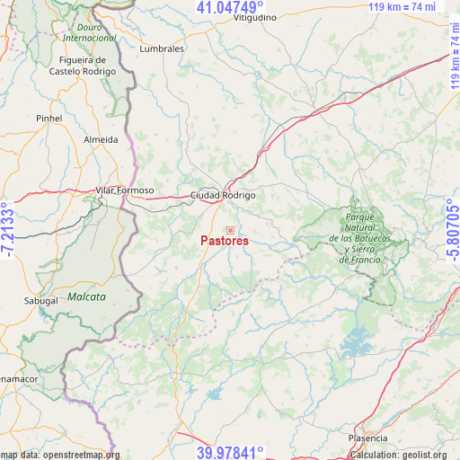
Pastores GPS coordinates[2]
40° 30' 54.288" North, 6° 30' 36.648" West
| Map corner | latitude | longitude |
|---|---|---|
| Upper-left | 41.04749°, | -7.2133° |
| Center: | 40.51508°, | -6.51018° |
| Lower-right: | 39.97841°, | -5.80705° |
| Map W x H: | 118.9×118.9 km | = 73.9×73.9mi |
| max Lat: | 43.74134° ⇑61.5% North |
| Pastores: | 40.51508° |
| min Lat: | ⇓38.5% South 27.64134° |
| min Long | Pastores | max Long |
| -18.00367° | -6.51018° | 4.2899° |
| W 8.7%⇐ | ⇒91.3% E |
Elevation
Elevation of Pastores is 767 m = 2516 ft, and this is 169 m = 554 ft above average elevation for this country.
| Max E: |
1682 m = 5518 ft | 36.5% |
| Pastores | 767 m 2516 ft | |
| Avg. | 598 m = 1962 ft | |
Min E: |
0 m = 0 ft | 63.5% |
See also: Spain elevation on elevation.city.
Geographical zone
Pastores is located in North temperate zone (between Tropic of Cancer and the Arctic Circle). Distance of this Northern Tropic circle is 1898.9 km =1179.9 mi to South.| Distance of | km | miles | from Pastores |
|---|---|---|---|
| North Pole | 5502.2 | 3418.9 | to North |
| Arctic Circle | 2896.3 | 1799.7 | to North |
| Tropic Cancer | 1898.9 | 1179.9 | to South |
| Equator | 4504.9 | 2799.2 | to South |


Nearby cities:
15 places around Pastores: (largest is in red/bold)
• Agallas
9.4 km =5.8 mi,  141°
141°
• Campillo de Azaba
15 km =9.3 mi,  267°
267°
• Carpio de Azaba
14.6 km =9.1 mi,  307°
307°
• Ciudad Rodrigo
9.6 km =6 mi,  348°
348°
• Espeja
18.3 km =11.4 mi,  287°
287°
• Fuenteguinaldo
16.9 km =10.5 mi,  235°
235°
• Herguijuela de Ciudad Rodrigo
6.3 km =3.9 mi,  188°
188°
• Ituero de Azaba
15.8 km =9.8 mi,  257°
257°
• Martiago
7 km =4.3 mi,  165°
165°
• Robleda
16.7 km =10.4 mi,  209°
209°
• Saelices el Chico
20.1 km =12.5 mi,  329°
329°
• Serradilla del Arroyo
12.7 km =7.9 mi,  86°
86°
• Serradilla del Llano
13.1 km =8.1 mi,  97°
97°
• Tenebrón
17.9 km =11.1 mi,  47°
47°
• Zamarra
4.9 km =3 mi,  84°
84°
Sources, notices
• [Note1] Compared only with cities in Spain existing in our database
• [Src1] Map data: © OpenStreetMap contributors (CC-BY-SA)
• [Src2] Other city data from geonames.org with taken over terms of usage.
• [Src3] Geographical zone / Annual Mean Temperature by Robert A. Rohde @ Wikipedia
