Ciudad Rodrigo geodata
Ciudad Rodrigo (Castille and León) is a seat of a third-order administrative division; located in Spain in Europe/Madrid (GMT+2) time zone. With population of 14,080 people, there are 656 cities with bigger population in this country. Compared to other cities in Spain, 59.8% of cities are located further ↑North; 91.4% of cities are located further →East and 50.8% of cities have higher elevation than Ciudad Rodrigo. Note1
Administrative division(s):
- Level 1: Castille and León
- Level 2: Provincia de Salamanca
- Level 3: Ciudad Rodrigo


Ciudad Rodrigo GPS coordinates[2]
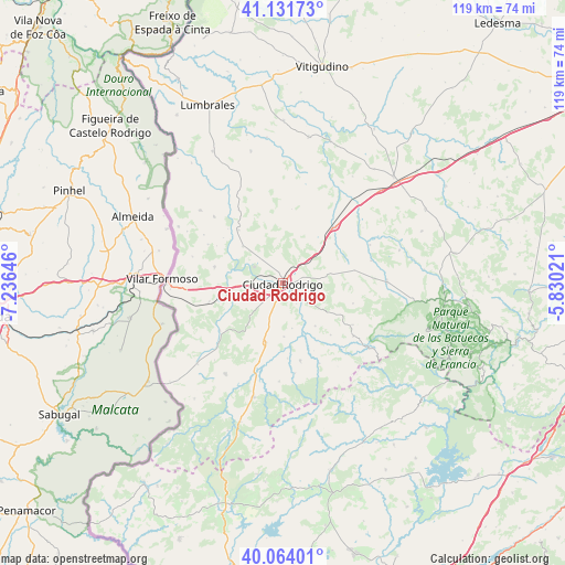
40° 36' 0" North, 6° 31' 59.988" West
| Map corner | latitude | longitude |
|---|---|---|
| Upper-left | 41.13173°, | -7.23646° |
| Center: | 40.6°, | -6.53333° |
| Lower-right: | 40.06401°, | -5.83021° |
| Map W x H: | 118.7×118.7 km | = 73.8×73.8mi |
| max Lat: | 43.74134° ⇑59.8% North |
| Ciudad Rodrigo: | 40.6° |
| min Lat: | ⇓40.2% South 27.64134° |
| min Long | Ciudad Rodrigo | max Long |
| -18.00367° | -6.53333° | 4.2899° |
| W 8.6%⇐ | ⇒91.4% E |
Elevation
Elevation of Ciudad Rodrigo is 650 m = 2133 ft, and this is 52 m = 171 ft above average elevation for this country.
| Max E: |
1682 m = 5518 ft | 50.8% |
| Ciudad Rodrigo | 650 m 2133 ft | |
| Avg. | 598 m = 1962 ft | |
Min E: |
0 m = 0 ft | 49.2% |
See also: Spain elevation on elevation.city.
Geographical zone
Ciudad Rodrigo is located in North temperate zone (between Tropic of Cancer and the Arctic Circle). Distance of this Northern Tropic circle is 1908.4 km =1185.8 mi to South.| Distance of | km | miles | from Ciudad Rodrigo |
|---|---|---|---|
| North Pole | 5492.8 | 3413.1 | to North |
| Arctic Circle | 2886.9 | 1793.8 | to North |
| Tropic Cancer | 1908.4 | 1185.8 | to South |
| Equator | 4514.3 | 2805.1 | to South |


Nearby cities:
15 places around Ciudad Rodrigo: (largest is in red/bold)
• Agallas
18.5 km =11.5 mi,  155°
155°
• Campillo de Azaba
16.4 km =10.2 mi,  232°
232°
• Carpio de Azaba
9.6 km =6 mi,  267°
267°
• Castillejo de Martín Viejo
13.9 km =8.6 mi,  320°
320°
• Espeja
15.9 km =9.9 mi,  256°
256°
• Gallegos de Argañán
14.7 km =9.1 mi,  283°
283°
• Herguijuela de Ciudad Rodrigo
15.8 km =9.8 mi,  176°
176°
• Martiago
16.6 km =10.3 mi,  167°
167°
• Pastores
9.6 km =6 mi, 168°
• Saelices el Chico
11.4 km =7.1 mi,  312°
312°
• Sancti Spíritus
16.3 km =10.1 mi,  43°
43°
• Serradilla del Arroyo
17 km =10.6 mi,  120°
120°
• Serradilla del Llano
18.6 km =11.6 mi,  126°
126°
• Tenebrón
15.3 km =9.5 mi,  79°
79°
• Zamarra
11.3 km =7 mi,  142°
142°
Sources, notices
• [Note1] Compared only with cities in Spain existing in our database
• [Src1] Map data: © OpenStreetMap contributors (CC-BY-SA)
• [Src2] Other city data from geonames.org with taken over terms of usage.
• [Src3] Geographical zone / Annual Mean Temperature by Robert A. Rohde @ Wikipedia
