Sebúlcor geodata
Sebúlcor (Castille and León) is a seat of a third-order administrative division; located in Spain in Europe/Madrid (GMT+2) time zone. With population of 299 people, there are 4508 cities with bigger population in this country. Compared to other cities in Spain, 54.8% of cities are located further ↓South; 58.1% of cities are located further →East and 84.1% of cities have lower elevation than Sebúlcor. Note1
Administrative division(s):
- Level 1: Castille and León
- Level 2: Provincia de Segovia
- Level 3: Sebúlcor


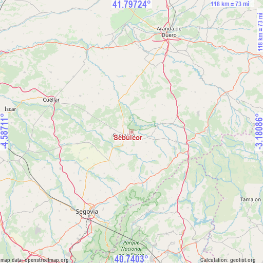
Sebúlcor GPS coordinates[2]
41° 16' 15.276" North, 3° 53' 2.328" West
| Map corner | latitude | longitude |
|---|---|---|
| Upper-left | 41.79724°, | -4.58711° |
| Center: | 41.27091°, | -3.88398° |
| Lower-right: | 40.7403°, | -3.18086° |
| Map W x H: | 117.5×117.5 km | = 73×73mi |
| max Lat: | 43.74134° ⇑45.2% North |
| Sebúlcor: | 41.27091° |
| min Lat: | ⇓54.8% South 27.64134° |
| min Long | Sebúlcor | max Long |
| -18.00367° | -3.88398° | 4.2899° |
| W 41.9%⇐ | ⇒58.1% E |
Elevation
Elevation of Sebúlcor is 941 m = 3087 ft, and this is 343 m = 1125 ft above average elevation for this country.
| Max E: |
1682 m = 5518 ft | 15.9% |
| Sebúlcor | 941 m 3087 ft | |
| Avg. | 598 m = 1962 ft | |
Min E: |
0 m = 0 ft | 84.1% |
See also: Spain elevation on elevation.city.
Geographical zone
Sebúlcor is located in North temperate zone (between Tropic of Cancer and the Arctic Circle). Distance of this Northern Tropic circle is 1983 km =1232.2 mi to South.| Distance of | km | miles | from Sebúlcor |
|---|---|---|---|
| North Pole | 5418.2 | 3366.7 | to North |
| Arctic Circle | 2812.3 | 1747.5 | to North |
| Tropic Cancer | 1983 | 1232.2 | to South |
| Equator | 4588.9 | 2851.4 | to South |


Nearby cities:
15 places around Sebúlcor: (largest is in red/bold)
• Aldealcorvo
8.3 km =5.2 mi,  110°
110°
• Arevalillo de Cega
12.1 km =7.5 mi,  182°
182°
• Cabezuela
5.6 km =3.5 mi,  225°
225°
• Cantalejo
4 km =2.5 mi,  248°
248°
• Carrascal del Río
10.9 km =6.8 mi,  353°
353°
• Cobos de Fuentidueña
12.9 km =8 mi,  343°
343°
• Muñoveros
12.3 km =7.6 mi,  207°
207°
• Navalilla
8.8 km =5.5 mi,  332°
332°
• Puebla de Pedraza
7.7 km =4.8 mi,  198°
198°
• Rebollo
8.9 km =5.5 mi,  165°
165°
• San Pedro de Gaíllos
8 km =5 mi,  128°
128°
• Sepúlveda
12.2 km =7.6 mi,  76°
76°
• Valle de Tabladillo
10.9 km =6.8 mi,  19°
19°
• Valleruela de Pedraza
12 km =7.5 mi,  147°
147°
• Veganzones
12.6 km =7.8 mi, 226°
Sources, notices
• [Note1] Compared only with cities in Spain existing in our database
• [Src1] Map data: © OpenStreetMap contributors (CC-BY-SA)
• [Src2] Other city data from geonames.org with taken over terms of usage.
• [Src3] Geographical zone / Annual Mean Temperature by Robert A. Rohde @ Wikipedia
