Navalilla geodata
Navalilla (Castille and León) is a seat of a third-order administrative division; located in Spain in Europe/Madrid (GMT+2) time zone. With population of 137 people, there are 5525 cities with bigger population in this country. Compared to other cities in Spain, 56.1% of cities are located further ↓South; 58.8% of cities are located further →East and 80.5% of cities have lower elevation than Navalilla. Note1
Administrative division(s):
- Level 1: Castille and León
- Level 2: Provincia de Segovia
- Level 3: Navalilla


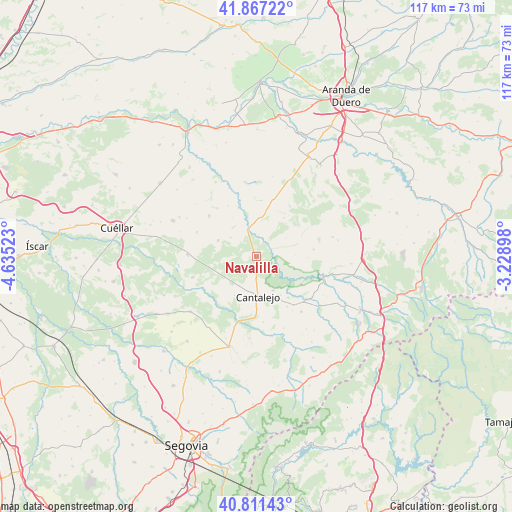
Navalilla GPS coordinates[2]
41° 20' 29.256" North, 3° 55' 55.596" West
| Map corner | latitude | longitude |
|---|---|---|
| Upper-left | 41.86722°, | -4.63523° |
| Center: | 41.34146°, | -3.93211° |
| Lower-right: | 40.81143°, | -3.22898° |
| Map W x H: | 117.4×117.4 km | = 72.9×72.9mi |
| max Lat: | 43.74134° ⇑43.9% North |
| Navalilla: | 41.34146° |
| min Lat: | ⇓56.1% South 27.64134° |
| min Long | Navalilla | max Long |
| -18.00367° | -3.93211° | 4.2899° |
| W 41.2%⇐ | ⇒58.8% E |
Elevation
Elevation of Navalilla is 902 m = 2959 ft, and this is 304 m = 997 ft above average elevation for this country.
| Max E: |
1682 m = 5518 ft | 19.5% |
| Navalilla | 902 m 2959 ft | |
| Avg. | 598 m = 1962 ft | |
Min E: |
0 m = 0 ft | 80.5% |
See also: Spain elevation on elevation.city.
Geographical zone
Navalilla is located in North temperate zone (between Tropic of Cancer and the Arctic Circle). Distance of this Northern Tropic circle is 1990.8 km =1237 mi to South.| Distance of | km | miles | from Navalilla |
|---|---|---|---|
| North Pole | 5410.3 | 3361.8 | to North |
| Arctic Circle | 2804.4 | 1742.6 | to North |
| Tropic Cancer | 1990.8 | 1237 | to South |
| Equator | 4596.7 | 2856.3 | to South |


Nearby cities:
15 places around Navalilla: (largest is in red/bold)
• Cabezuela
11.7 km =7.3 mi,  179°
179°
• Cantalejo
9.3 km =5.8 mi, 177°
• Carrascal del Río
4.1 km =2.5 mi,  43°
43°
• Castro de Fuentidueña
10.9 km =6.8 mi, 36°
• Castrojimeno
9.4 km =5.8 mi,  49°
49°
• Castroserracín
12.3 km =7.6 mi,  62°
62°
• Cobos de Fuentidueña
4.6 km =2.9 mi,  5°
5°
• Fuente el Olmo de Fuentidueña
7.1 km =4.4 mi,  306°
306°
• Fuentepiñel
11.2 km =7 mi,  304°
304°
• Fuentesoto
12.9 km =8 mi, 5°
• Fuentidueña
11.9 km =7.4 mi,  340°
340°
• Sebúlcor
8.8 km =5.5 mi,  152°
152°
• Torrecilla del Pinar
9.6 km =6 mi,  291°
291°
• Urueñas
13.3 km =8.3 mi,  83°
83°
• Valle de Tabladillo
8.1 km =5 mi,  72°
72°
Sources, notices
• [Note1] Compared only with cities in Spain existing in our database
• [Src1] Map data: © OpenStreetMap contributors (CC-BY-SA)
• [Src2] Other city data from geonames.org with taken over terms of usage.
• [Src3] Geographical zone / Annual Mean Temperature by Robert A. Rohde @ Wikipedia
