Sasamón geodata
Sasamón (Castille and León) is a seat of a third-order administrative division; located in Spain in Europe/Madrid (GMT+2) time zone. With population of 1,309 people, there are 2633 cities with bigger population in this country. Compared to other cities in Spain, 85.3% of cities are located further ↓South; 60.4% of cities are located further →East and 70.3% of cities have lower elevation than Sasamón. Note1
Administrative division(s):
- Level 1: Castille and León
- Level 2: Provincia de Burgos
- Level 3: Sasamón


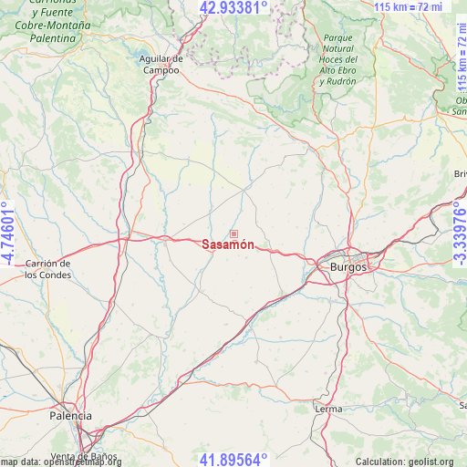
Sasamón GPS coordinates[2]
42° 25' 0.732" North, 4° 2' 34.368" West
| Map corner | latitude | longitude |
|---|---|---|
| Upper-left | 42.93381°, | -4.74601° |
| Center: | 42.41687°, | -4.04288° |
| Lower-right: | 41.89564°, | -3.33976° |
| Map W x H: | 115.4×115.4 km | = 71.7×71.7mi |
| max Lat: | 43.74134° ⇑14.7% North |
| Sasamón: | 42.41687° |
| min Lat: | ⇓85.3% South 27.64134° |
| min Long | Sasamón | max Long |
| -18.00367° | -4.04288° | 4.2899° |
| W 39.6%⇐ | ⇒60.4% E |
Elevation
Elevation of Sasamón is 816 m = 2677 ft, and this is 218 m = 715 ft above average elevation for this country.
| Max E: |
1682 m = 5518 ft | 29.7% |
| Sasamón | 816 m 2677 ft | |
| Avg. | 598 m = 1962 ft | |
Min E: |
0 m = 0 ft | 70.3% |
See also: Spain elevation on elevation.city.
Geographical zone
Sasamón is located in North temperate zone (between Tropic of Cancer and the Arctic Circle). Distance of this Northern Tropic circle is 2110.4 km =1311.3 mi to South.| Distance of | km | miles | from Sasamón |
|---|---|---|---|
| North Pole | 5290.7 | 3287.5 | to North |
| Arctic Circle | 2684.9 | 1668.3 | to North |
| Tropic Cancer | 2110.4 | 1311.3 | to South |
| Equator | 4716.3 | 2930.6 | to South |


Nearby cities:
15 places around Sasamón: (largest is in red/bold)
• Castellanos de Castro
9.9 km =6.2 mi,  175°
175°
• Grijalba
6.4 km =4 mi,  283°
283°
• Hontanas
11.5 km =7.1 mi, 180°
• Isar
11.1 km =6.9 mi,  123°
123°
• Manciles
9.2 km =5.7 mi,  60°
60°
• Padilla de Abajo
11 km =6.8 mi,  264°
264°
• Pedrosa del Páramo
6.5 km =4 mi, 64°
• Sordillos
7.3 km =4.5 mi,  313°
313°
• Susinos del Páramo
11.4 km =7.1 mi, 57°
• Tobar
11.3 km =7 mi,  48°
48°
• Villadiego
11.3 km =7 mi,  13°
13°
• Villamayor de Treviño
7.9 km =4.9 mi, 307°
• Villanueva de Argaño
9.8 km =6.1 mi,  114°
114°
• Villasandino
7.5 km =4.7 mi,  226°
226°
• Villegas
6.1 km =3.8 mi,  19°
19°
Sources, notices
• [Note1] Compared only with cities in Spain existing in our database
• [Src1] Map data: © OpenStreetMap contributors (CC-BY-SA)
• [Src2] Other city data from geonames.org with taken over terms of usage.
• [Src3] Geographical zone / Annual Mean Temperature by Robert A. Rohde @ Wikipedia
