Tobar geodata
Tobar (Castille and León) is a seat of a third-order administrative division; located in Spain in Europe/Madrid (GMT+2) time zone. With population of 41 people, there are 6557 cities with bigger population in this country. Compared to other cities in Spain, 86.9% of cities are located further ↓South; 58.9% of cities are located further →East and 78% of cities have lower elevation than Tobar. Note1


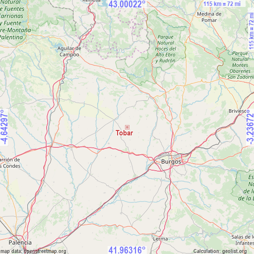
Tobar GPS coordinates[2]
42° 29' 1.824" North, 3° 56' 23.424" West
| Map corner | latitude | longitude |
|---|---|---|
| Upper-left | 43.00022°, | -4.64297° |
| Center: | 42.48384°, | -3.93984° |
| Lower-right: | 41.96316°, | -3.23672° |
| Map W x H: | 115.3×115.3 km | = 71.6×71.6mi |
| max Lat: | 43.74134° ⇑13.1% North |
| Tobar: | 42.48384° |
| min Lat: | ⇓86.9% South 27.64134° |
| min Long | Tobar | max Long |
| -18.00367° | -3.93984° | 4.2899° |
| W 41.1%⇐ | ⇒58.9% E |
Elevation
Elevation of Tobar is 879 m = 2884 ft, and this is 281 m = 922 ft above average elevation for this country.
| Max E: |
1682 m = 5518 ft | 22% |
| Tobar | 879 m 2884 ft | |
| Avg. | 598 m = 1962 ft | |
Min E: |
0 m = 0 ft | 78% |
See also: Spain elevation on elevation.city.
Geographical zone
Tobar is located in North temperate zone (between Tropic of Cancer and the Arctic Circle). Distance of this Northern Tropic circle is 2117.8 km =1315.9 mi to South.| Distance of | km | miles | from Tobar |
|---|---|---|---|
| North Pole | 5283.3 | 3282.9 | to North |
| Arctic Circle | 2677.4 | 1663.7 | to North |
| Tropic Cancer | 2117.8 | 1315.9 | to South |
| Equator | 4723.8 | 2935.2 | to South |


Nearby cities:
15 places around Tobar: (largest is in red/bold)
• Grijalba
15.9 km =9.9 mi,  247°
247°
• Hornillos del Camino
16.2 km =10.1 mi,  175°
175°
• Huérmeces
14.5 km =9 mi,  72°
72°
• Isar
13.6 km =8.5 mi, 176°
• Manciles
3 km =1.9 mi,  187°
187°
• Montorio
17.4 km =10.8 mi,  49°
49°
• Pedrosa del Páramo
5.3 km =3.3 mi,  209°
209°
• Santibáñez-Zarzaguda
12.9 km =8 mi,  91°
91°
• Sasamón
11.3 km =7 mi,  228°
228°
• Sordillos
13.9 km =8.6 mi,  259°
259°
• Susinos del Páramo
1.8 km =1.1 mi,  140°
140°
• Villadiego
6.7 km =4.2 mi,  301°
301°
• Villamayor de Treviño
14.9 km =9.3 mi, 259°
• Villanueva de Argaño
11.5 km =7.1 mi, 177°
• Villegas
6.6 km =4.1 mi, 255°
Sources, notices
• [Note1] Compared only with cities in Spain existing in our database
• [Src1] Map data: © OpenStreetMap contributors (CC-BY-SA)
• [Src2] Other city data from geonames.org with taken over terms of usage.
• [Src3] Geographical zone / Annual Mean Temperature by Robert A. Rohde @ Wikipedia
