Sant Vicenç de Castellet geodata
Sant Vicenç de Castellet (Catalonia) is a populated place; located in Spain in Europe/Madrid (GMT+2) time zone. With population of 8,096 people, there are 928 cities with bigger population in this country. Compared to other cities in Spain, 65.1% of cities are located further ↓South; 92.9% of cities are located further ←West and 81.3% of cities have higher elevation than Sant Vicenç de Castellet. Note1
Administrative division(s):
- Level 1: Catalonia
- Level 2: Província de Barcelona
- Level 3: Castellbell i el Vilar
Current local time in Sant Vicenç de Castellet:
10:48 PM, ThursdayDifference from your time zone: hours


Sant Vicenç de Castellet GPS coordinates[2]
41° 40' 0.012" North, 1° 52' 0.012" East
| Map corner | latitude | longitude |
|---|---|---|
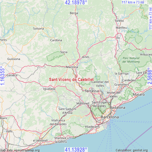
| Upper-left | 42.18978°, | 1.16355° |
| Center: | 41.66667°, | 1.86667° |
| Lower-right: | 41.13928°, | 2.5698° |
| Map W x H: | 116.8×116.8 km | = 72.6×72.6mi |
| max Lat: | 43.74134° ⇑34.9% North |
| Sant Vicenç de Castellet: | 41.66667° |
| min Lat: | ⇓65.1% South 27.64134° |
| min Long | Sant Vicenç de | max Long |
| -18.00367° | 1.86667° | 4.2899° |
| W 92.9%⇐ | ⇒7.1% E |
Elevation
Elevation of Sant Vicenç de Castellet is 198 m = 650 ft, and this is 400 m = 1312 ft below average elevation for this country.
| Max E: |
1682 m = 5518 ft | 81.3% |
| Avg. | 598 m = 1962 ft | |
| Sant Vicenç de Castellet | 198 m = 650 ft | |
Min E: |
0 m = 0 ft | 18.7% |
See also: Spain elevation on elevation.city.
Geographical zone
Sant Vicenç de Castellet is located in North temperate zone (between Tropic of Cancer and the Arctic Circle). Distance of this Northern Tropic circle is 2027 km =1259.5 mi to South.| Distance of | km | miles | from Sant Vicenç de Castellet |
|---|---|---|---|
| North Pole | 5374.2 | 3339.4 | to North |
| Arctic Circle | 2768.3 | 1720.1 | to North |
| Tropic Cancer | 2027 | 1259.5 | to South |
| Equator | 4632.9 | 2878.7 | to South |


Nearby cities:
15 places around Sant Vicenç de Castellet: (largest is in red/bold)
• Callús
14.5 km =9 mi,  331°
331°
• Castellfollit del Boix
13.8 km =8.6 mi,  270°
270°
• Collbató
11.2 km =7 mi,  197°
197°
• Esparreguera
14.3 km =8.9 mi,  178°
178°
• Manresa
7.7 km =4.8 mi, 332°
• Monistrol de Montserrat
5.7 km =3.5 mi,  193°
193°
• Mura
9.8 km =6.1 mi,  68°
68°
• Navarcles
9.9 km =6.2 mi,  17°
17°
• Olesa de Montserrat
13.9 km =8.6 mi,  170°
170°
• Sant Fruitós de Bages
9.3 km =5.8 mi,  0°
0°
• Sant Joan de Vilatorrada
10.2 km =6.3 mi, 329°
• Sant Salvador de Guardiola
8.5 km =5.3 mi,  282°
282°
• Santpedor
13.1 km =8.1 mi,  352°
352°
• Talamanca
12.1 km =7.5 mi,  49°
49°
• Viladecavalls
14.7 km =9.1 mi,  151°
151°
Sources, notices
• [Note1] Compared only with cities in Spain existing in our database
• [Src1] Map data: © OpenStreetMap contributors (CC-BY-SA)
• [Src2] Other city data from geonames.org with taken over terms of usage.
• [Src3] Geographical zone / Annual Mean Temperature by Robert A. Rohde @ Wikipedia
