Manresa geodata
Manresa (Catalonia) is a populated place; located in Spain in Europe/Madrid (GMT+2) time zone. With population of 76,558 people, there are 121 cities with bigger population in this country. Compared to other cities in Spain, 66.8% of cities are located further ↓South; 92.7% of cities are located further ←West and 78.8% of cities have higher elevation than Manresa. Note1
Administrative division(s):
- Level 1: Catalonia
- Level 2: Província de Barcelona
- Level 3: Sant Fruitós de Bages


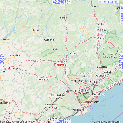
Manresa GPS coordinates[2]
41° 43' 41.34" North, 1° 49' 26.364" East
| Map corner | latitude | longitude |
|---|---|---|
| Upper-left | 42.25076°, | 1.12087° |
| Center: | 41.72815°, | 1.82399° |
| Lower-right: | 41.20126°, | 2.52712° |
| Map W x H: | 116.7×116.7 km | = 72.5×72.5mi |
| max Lat: | 43.74134° ⇑33.2% North |
| Manresa: | 41.72815° |
| min Lat: | ⇓66.8% South 27.64134° |
| min Long | Manresa | max Long |
| -18.00367° | 1.82399° | 4.2899° |
| W 92.7%⇐ | ⇒7.3% E |
Elevation
Elevation of Manresa is 241 m = 791 ft, and this is 357 m = 1171 ft below average elevation for this country.
| Max E: |
1682 m = 5518 ft | 78.8% |
| Avg. | 598 m = 1962 ft | |
| Manresa | 241 m = 791 ft | |
Min E: |
0 m = 0 ft | 21.2% |
See also: Manresa elevation on elevation.city.
Geographical zone
Manresa is located in North temperate zone (between Tropic of Cancer and the Arctic Circle). Distance of this Northern Tropic circle is 2033.8 km =1263.7 mi to South.| Distance of | km | miles | from Manresa |
|---|---|---|---|
| North Pole | 5367.3 | 3335.1 | to North |
| Arctic Circle | 2761.4 | 1715.9 | to North |
| Tropic Cancer | 2033.8 | 1263.7 | to South |
| Equator | 4639.7 | 2883 | to South |


Nearby cities:
15 places around Manresa: (largest is in red/bold)
• Callús
6.8 km =4.2 mi,  330°
330°
• Castellfollit del Boix
12.4 km =7.7 mi,  236°
236°
• Castellnou de Bages
11.9 km =7.4 mi,  5°
5°
• Monistrol de Montserrat
12.6 km =7.8 mi,  170°
170°
• Mura
13 km =8.1 mi,  104°
104°
• Navarcles
7.1 km =4.4 mi,  68°
68°
• Rajadell
9.8 km =6.1 mi,  269°
269°
• Sallent
12.4 km =7.7 mi,  28°
28°
• Sant Fruitós de Bages
4.3 km =2.7 mi,  55°
55°
• Sant Joan de Vilatorrada
2.5 km =1.6 mi,  320°
320°
• Sant Salvador de Guardiola
6.9 km =4.3 mi,  223°
223°
• Sant Vicenç de Castellet
7.7 km =4.8 mi,  152°
152°
• Santpedor
6.4 km =4 mi,  17°
17°
• Súria
13.2 km =8.2 mi, 332°
• Talamanca
12.8 km =8 mi,  85°
85°
Sources, notices
• [Note1] Compared only with cities in Spain existing in our database
• [Src1] Map data: © OpenStreetMap contributors (CC-BY-SA)
• [Src2] Other city data from geonames.org with taken over terms of usage.
• [Src3] Geographical zone / Annual Mean Temperature by Robert A. Rohde @ Wikipedia
