Santpedor geodata
Santpedor (Catalonia) is a seat of a third-order administrative division; located in Spain in Europe/Madrid (GMT+2) time zone. In our database, there are 6762 cities with bigger population. Compared to other cities in Spain, 68.1% of cities are located further ↓South; 92.8% of cities are located further ←West and 74% of cities have higher elevation than Santpedor. Note1


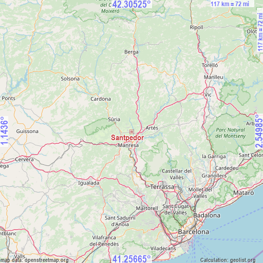
Santpedor GPS coordinates[2]
41° 46' 59.124" North, 1° 50' 48.228" East
| Map corner | latitude | longitude |
|---|---|---|
| Upper-left | 42.30525°, | 1.1436° |
| Center: | 41.78309°, | 1.84673° |
| Lower-right: | 41.25665°, | 2.54985° |
| Map W x H: | 116.6×116.6 km | = 72.5×72.5mi |
| max Lat: | 43.74134° ⇑31.9% North |
| Santpedor: | 41.78309° |
| min Lat: | ⇓68.1% South 27.64134° |
| min Long | Santpedor | max Long |
| -18.00367° | 1.84673° | 4.2899° |
| W 92.8%⇐ | ⇒7.2% E |
Elevation
Elevation of Santpedor is 315 m = 1033 ft, and this is 283 m = 928 ft below average elevation for this country.
| Max E: |
1682 m = 5518 ft | 74% |
| Avg. | 598 m = 1962 ft | |
| Santpedor | 315 m = 1033 ft | |
Min E: |
0 m = 0 ft | 26% |
See also: Spain elevation on elevation.city.
Geographical zone
Santpedor is located in North temperate zone (between Tropic of Cancer and the Arctic Circle). Distance of this Northern Tropic circle is 2039.9 km =1267.5 mi to South.| Distance of | km | miles | from Santpedor |
|---|---|---|---|
| North Pole | 5361.2 | 3331.3 | to North |
| Arctic Circle | 2755.3 | 1712.1 | to North |
| Tropic Cancer | 2039.9 | 1267.5 | to South |
| Equator | 4645.8 | 2886.8 | to South |


Nearby cities:
15 places around Santpedor: (largest is in red/bold)
• Artés
9.1 km =5.7 mi,  79°
79°
• Balsareny
9.2 km =5.7 mi,  14°
14°
• Calders
11.6 km =7.2 mi,  86°
86°
• Callús
5.2 km =3.2 mi,  268°
268°
• Castellnou de Bages
5.8 km =3.6 mi,  352°
352°
• Manresa
6.4 km =4 mi,  197°
197°
• Navarcles
5.9 km =3.7 mi,  126°
126°
• Navàs
13.2 km =8.2 mi, 11°
• Sallent
6.3 km =3.9 mi,  40°
40°
• Sant Fruitós de Bages
4 km =2.5 mi,  155°
155°
• Sant Joan de Vilatorrada
5.4 km =3.4 mi,  219°
219°
• Sant Salvador de Guardiola
12.9 km =8 mi,  210°
210°
• Sant Vicenç de Castellet
13.1 km =8.1 mi,  172°
172°
• Súria
9.8 km =6.1 mi,  304°
304°
• Talamanca
12 km =7.5 mi,  115°
115°
Sources, notices
• [Note1] Compared only with cities in Spain existing in our database
• [Src1] Map data: © OpenStreetMap contributors (CC-BY-SA)
• [Src2] Other city data from geonames.org with taken over terms of usage.
• [Src3] Geographical zone / Annual Mean Temperature by Robert A. Rohde @ Wikipedia
