Talamanca geodata
Talamanca (Catalonia) is a seat of a third-order administrative division; located in Spain in Europe/Madrid (GMT+2) time zone. With population of 116 people, there are 5741 cities with bigger population in this country. Compared to other cities in Spain, 67% of cities are located further ↓South; 93.4% of cities are located further ←West and 57.2% of cities have higher elevation than Talamanca. Note1


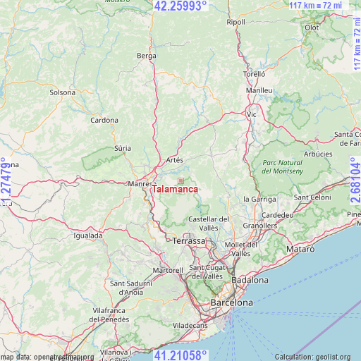
Talamanca GPS coordinates[2]
41° 44' 14.64" North, 1° 58' 40.476" East
| Map corner | latitude | longitude |
|---|---|---|
| Upper-left | 42.25993°, | 1.27479° |
| Center: | 41.7374°, | 1.97791° |
| Lower-right: | 41.21058°, | 2.68104° |
| Map W x H: | 116.7×116.7 km | = 72.5×72.5mi |
| max Lat: | 43.74134° ⇑33% North |
| Talamanca: | 41.7374° |
| min Lat: | ⇓67% South 27.64134° |
| min Long | Talamanca | max Long |
| -18.00367° | 1.97791° | 4.2899° |
| W 93.4%⇐ | ⇒6.6% E |
Elevation
Elevation of Talamanca is 560 m = 1837 ft, and this is 38 m = 125 ft below average elevation for this country.
| Max E: |
1682 m = 5518 ft | 57.2% |
| Avg. | 598 m = 1962 ft | |
| Talamanca | 560 m = 1837 ft | |
Min E: |
0 m = 0 ft | 42.8% |
See also: Spain elevation on elevation.city.
Geographical zone
Talamanca is located in North temperate zone (between Tropic of Cancer and the Arctic Circle). Distance of this Northern Tropic circle is 2034.8 km =1264.4 mi to South.| Distance of | km | miles | from Talamanca |
|---|---|---|---|
| North Pole | 5366.3 | 3334.5 | to North |
| Arctic Circle | 2760.4 | 1715.2 | to North |
| Tropic Cancer | 2034.8 | 1264.4 | to South |
| Equator | 4640.8 | 2883.7 | to South |


Nearby cities:
15 places around Talamanca: (largest is in red/bold)
• Artés
7 km =4.3 mi,  343°
343°
• Avinyó
14.1 km =8.8 mi,  357°
357°
• Calders
5.8 km =3.6 mi,  7°
7°
• Castellterçol
11.6 km =7.2 mi,  83°
83°
• Gallifa
12.3 km =7.6 mi,  113°
113°
• Granera
6.8 km =4.2 mi,  99°
99°
• Manresa
12.8 km =8 mi,  265°
265°
• Moià
12.9 km =8 mi,  50°
50°
• Monistrol de Calders
4.1 km =2.5 mi, 51°
• Mura
4.2 km =2.6 mi,  182°
182°
• Navarcles
6.4 km =4 mi,  284°
284°
• Sallent
12 km =7.5 mi,  325°
325°
• Sant Fruitós de Bages
9.3 km =5.8 mi, 278°
• Sant Vicenç de Castellet
12.1 km =7.5 mi,  229°
229°
• Santpedor
12 km =7.5 mi,  295°
295°
Sources, notices
• [Note1] Compared only with cities in Spain existing in our database
• [Src1] Map data: © OpenStreetMap contributors (CC-BY-SA)
• [Src2] Other city data from geonames.org with taken over terms of usage.
• [Src3] Geographical zone / Annual Mean Temperature by Robert A. Rohde @ Wikipedia
