Castellfollit del Boix geodata
Castellfollit del Boix (Catalonia) is a seat of a third-order administrative division; located in Spain in Europe/Madrid (GMT+2) time zone. In our database, there are 6762 cities with bigger population. Compared to other cities in Spain, 65.1% of cities are located further ↓South; 92.3% of cities are located further ←West and 60.2% of cities have higher elevation than Castellfollit del Boix. Note1
Administrative division(s):
- Level 1: Catalonia
- Level 2: Província de Barcelona
- Level 3: Castellfollit del Boix
Current local time in Castellfollit del Boix:
10:46 PM, ThursdayDifference from your time zone: hours


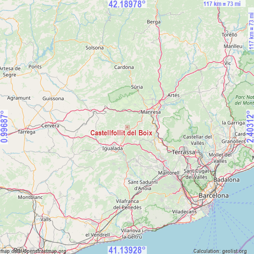
Castellfollit del Boix GPS coordinates[2]
41° 40' 0.012" North, 1° 42' 0" East
| Map corner | latitude | longitude |
|---|---|---|
| Upper-left | 42.18978°, | 0.99687° |
| Center: | 41.66667°, | 1.7° |
| Lower-right: | 41.13928°, | 2.40312° |
| Map W x H: | 116.8×116.8 km | = 72.6×72.6mi |
| max Lat: | 43.74134° ⇑34.9% North |
| Castellfollit del Boix: | 41.66667° |
| min Lat: | ⇓65.1% South 27.64134° |
| min Long | Castellfollit d | max Long |
| -18.00367° | 1.7° | 4.2899° |
| W 92.3%⇐ | ⇒7.7% E |
Elevation
Elevation of Castellfollit del Boix is 525 m = 1722 ft, and this is 73 m = 240 ft below average elevation for this country.
| Max E: |
1682 m = 5518 ft | 60.2% |
| Avg. | 598 m = 1962 ft | |
| Castellfollit del Boix | 525 m = 1722 ft | |
Min E: |
0 m = 0 ft | 39.8% |
See also: Spain elevation on elevation.city.
Geographical zone
Castellfollit del Boix is located in North temperate zone (between Tropic of Cancer and the Arctic Circle). Distance of this Northern Tropic circle is 2027 km =1259.5 mi to South.| Distance of | km | miles | from Castellfollit del Boix |
|---|---|---|---|
| North Pole | 5374.2 | 3339.4 | to North |
| Arctic Circle | 2768.3 | 1720.1 | to North |
| Tropic Cancer | 2027 | 1259.5 | to South |
| Equator | 4632.9 | 2878.7 | to South |


Nearby cities:
15 places around Castellfollit del Boix: (largest is in red/bold)
• Aguilar de Segarra
10.8 km =6.7 mi,  327°
327°
• Callús
14.5 km =9 mi,  28°
28°
• Castellolí
7.6 km =4.7 mi,  179°
179°
• Fonollosa
11 km =6.8 mi,  346°
346°
• Igualada
11.8 km =7.3 mi,  215°
215°
• Jorba
14.6 km =9.1 mi,  240°
240°
• La Pobla de Claramunt
12.6 km =7.8 mi,  188°
188°
• Manresa
12.4 km =7.7 mi,  56°
56°
• Monistrol de Montserrat
13.6 km =8.5 mi,  114°
114°
• Rajadell
6.8 km =4.2 mi,  4°
4°
• Sant Joan de Vilatorrada
12.3 km =7.6 mi,  44°
44°
• Sant Salvador de Guardiola
5.8 km =3.6 mi,  71°
71°
• Sant Vicenç de Castellet
13.8 km =8.6 mi,  90°
90°
• Vilanova del Camí
11.8 km =7.3 mi,  206°
206°
• Òdena
8.5 km =5.3 mi, 209°
Sources, notices
• [Note1] Compared only with cities in Spain existing in our database
• [Src1] Map data: © OpenStreetMap contributors (CC-BY-SA)
• [Src2] Other city data from geonames.org with taken over terms of usage.
• [Src3] Geographical zone / Annual Mean Temperature by Robert A. Rohde @ Wikipedia
