Lezo geodata
Lezo (Basque Country) is a seat of a third-order administrative division; located in Spain in Europe/Madrid (GMT+2) time zone. With population of 5,867 people, there are 1151 cities with bigger population in this country. Compared to other cities in Spain, 97.9% of cities are located further ↓South; 68.5% of cities are located further ←West and 97.6% of cities have higher elevation than Lezo. Note1


Lezo GPS coordinates[2]
43° 19' 17.112" North, 1° 53' 50.604" West
| Map corner | latitude | longitude |
|---|---|---|
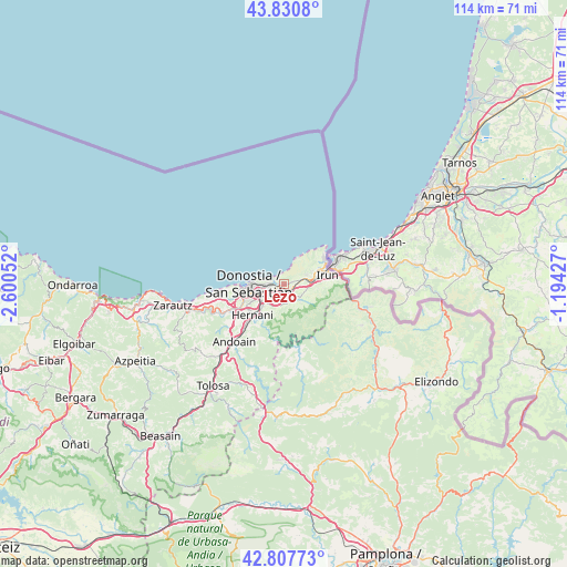
| Upper-left | 43.8308°, | -2.60052° |
| Center: | 43.32142°, | -1.89739° |
| Lower-right: | 42.80773°, | -1.19427° |
| Map W x H: | 113.8×113.8 km | = 70.7×70.7mi |
| max Lat: | 43.74134° ⇑2.1% North |
| Lezo: | 43.32142° |
| min Lat: | ⇓97.9% South 27.64134° |
| min Long | Lezo | max Long |
| -18.00367° | -1.89739° | 4.2899° |
| W 68.5%⇐ | ⇒31.5% E |
Elevation
Elevation of Lezo is 13 m = 43 ft, and this is 585 m = 1919 ft below average elevation for this country.
| Max E: |
1682 m = 5518 ft | 97.6% |
| Avg. | 598 m = 1962 ft | |
| Lezo | 13 m = 43 ft | |
Min E: |
0 m = 0 ft | 2.4% |
See also: Spain elevation on elevation.city.
Geographical zone
Lezo is located in North temperate zone (between Tropic of Cancer and the Arctic Circle). Distance of this Northern Tropic circle is 2211 km =1373.9 mi to South.| Distance of | km | miles | from Lezo |
|---|---|---|---|
| North Pole | 5190.2 | 3225 | to North |
| Arctic Circle | 2584.3 | 1605.8 | to North |
| Tropic Cancer | 2211 | 1373.9 | to South |
| Equator | 4816.9 | 2993.1 | to South |


Nearby cities:
15 places around Lezo: (largest is in red/bold)
• Andoain
15.6 km =9.7 mi,  221°
221°
• Arano
13.6 km =8.5 mi,  179°
179°
• Astigarraga
5.9 km =3.7 mi, 221°
• Bera
17.6 km =10.9 mi,  104°
104°
• Donostia / San Sebastián
6.3 km =3.9 mi,  261°
261°
• Errenteria
1.1 km =0.7 mi,  200°
200°
• Goizueta
16.8 km =10.4 mi,  170°
170°
• Hernani
8.9 km =5.5 mi,  226°
226°
• Hondarribia
9.7 km =6 mi,  57°
57°
• Irun
9 km =5.6 mi,  77°
77°
• Lasarte
11.7 km =7.3 mi,  239°
239°
• Oria
12.3 km =7.6 mi, 233°
• Pasaia
2.4 km =1.5 mi,  280°
280°
• Urnieta
11.2 km =7 mi, 222°
• Usurbil
13.5 km =8.4 mi,  245°
245°
Sources, notices
• [Note1] Compared only with cities in Spain existing in our database
• [Src1] Map data: © OpenStreetMap contributors (CC-BY-SA)
• [Src2] Other city data from geonames.org with taken over terms of usage.
• [Src3] Geographical zone / Annual Mean Temperature by Robert A. Rohde @ Wikipedia
