San Román geodata
San Román (Galicia) is a populated place; located in Spain in Europe/Madrid (GMT+2) time zone. With population of 1,987 people, there are 2180 cities with bigger population in this country. Compared to other cities in Spain, 93.4% of cities are located further ↓South; 94.4% of cities are located further →East and 50.6% of cities have lower elevation than San Román. Note1


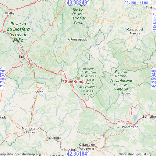
San Román GPS coordinates[2]
42° 52' 9.552" North, 7° 3' 45.396" West
| Map corner | latitude | longitude |
|---|---|---|
| Upper-left | 43.38249°, | -7.76574° |
| Center: | 42.86932°, | -7.06261° |
| Lower-right: | 42.35184°, | -6.35949° |
| Map W x H: | 114.6×114.6 km | = 71.2×71.2mi |
| max Lat: | 43.74134° ⇑6.6% North |
| San Román: | 42.86932° |
| min Lat: | ⇓93.4% South 27.64134° |
| min Long | San Román | max Long |
| -18.00367° | -7.06261° | 4.2899° |
| W 5.6%⇐ | ⇒94.4% E |
Elevation
Elevation of San Román is 665 m = 2182 ft, and this is 67 m = 220 ft above average elevation for this country.
| Max E: |
1682 m = 5518 ft | 49.4% |
| San Román | 665 m 2182 ft | |
| Avg. | 598 m = 1962 ft | |
Min E: |
0 m = 0 ft | 50.6% |
See also: Spain elevation on elevation.city.
Geographical zone
San Román is located in North temperate zone (between Tropic of Cancer and the Arctic Circle). Distance of this Northern Tropic circle is 2160.7 km =1342.6 mi to South.| Distance of | km | miles | from San Román |
|---|---|---|---|
| North Pole | 5240.4 | 3256.2 | to North |
| Arctic Circle | 2634.6 | 1637.1 | to North |
| Tropic Cancer | 2160.7 | 1342.6 | to South |
| Equator | 4766.6 | 2961.8 | to South |


Nearby cities:
15 places around San Román: (largest is in red/bold)
• Balboa
21.5 km =13.4 mi,  147°
147°
• Baralla
15.9 km =9.9 mi,  279°
279°
• Barjas
29.4 km =18.3 mi,  166°
166°
• Becerreá
8.4 km =5.2 mi,  259°
259°
• Candín
27.9 km =17.3 mi,  102°
102°
• Castroverde
27.8 km =17.3 mi,  310°
310°
• Fonsagrada
28.3 km =17.6 mi,  359°
359°
• Láncara
22.3 km =13.9 mi,  268°
268°
• Navia de Suarna
12 km =7.5 mi,  25°
25°
• O Páramo
21.3 km =13.2 mi,  294°
294°
• Samos
26.4 km =16.4 mi,  234°
234°
• San Antolín
24.3 km =15.1 mi,  39°
39°
• Trabadelo
28.7 km =17.8 mi, 148°
• Tríacastela
19.3 km =12 mi, 229°
• Vega de Valcarce
25.3 km =15.7 mi,  156°
156°
Sources, notices
• [Note1] Compared only with cities in Spain existing in our database
• [Src1] Map data: © OpenStreetMap contributors (CC-BY-SA)
• [Src2] Other city data from geonames.org with taken over terms of usage.
• [Src3] Geographical zone / Annual Mean Temperature by Robert A. Rohde @ Wikipedia
