Tríacastela geodata
Tríacastela (Galicia) is a populated place; located in Spain in Europe/Madrid (GMT+2) time zone. With population of 826 people, there are 3172 cities with bigger population in this country. Compared to other cities in Spain, 92.1% of cities are located further ↓South; 94.9% of cities are located further →East and 50.6% of cities have lower elevation than Tríacastela. Note1


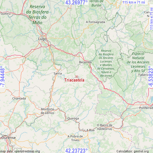
Tríacastela GPS coordinates[2]
42° 45' 20.34" North, 7° 14' 28.896" West
| Map corner | latitude | longitude |
|---|---|---|
| Upper-left | 43.26977°, | -7.94448° |
| Center: | 42.75565°, | -7.24136° |
| Lower-right: | 42.23723°, | -6.53823° |
| Map W x H: | 114.8×114.8 km | = 71.3×71.3mi |
| max Lat: | 43.74134° ⇑7.9% North |
| Tríacastela: | 42.75565° |
| min Lat: | ⇓92.1% South 27.64134° |
| min Long | Tríacastela | max Long |
| -18.00367° | -7.24136° | 4.2899° |
| W 5.1%⇐ | ⇒94.9% E |
Elevation
Elevation of Tríacastela is 665 m = 2182 ft, and this is 67 m = 220 ft above average elevation for this country.
| Max E: |
1682 m = 5518 ft | 49.4% |
| Tríacastela | 665 m 2182 ft | |
| Avg. | 598 m = 1962 ft | |
Min E: |
0 m = 0 ft | 50.6% |
See also: Spain elevation on elevation.city.
Geographical zone
Tríacastela is located in North temperate zone (between Tropic of Cancer and the Arctic Circle). Distance of this Northern Tropic circle is 2148.1 km =1334.8 mi to South.| Distance of | km | miles | from Tríacastela |
|---|---|---|---|
| North Pole | 5253.1 | 3264.1 | to North |
| Arctic Circle | 2647.2 | 1644.9 | to North |
| Tropic Cancer | 2148.1 | 1334.8 | to South |
| Equator | 4754 | 2954 | to South |


Nearby cities:
15 places around Tríacastela: (largest is in red/bold)
• A Pobra do Brollon
25.4 km =15.8 mi,  208°
208°
• Balboa
26.6 km =16.5 mi,  101°
101°
• Baralla
15.2 km =9.4 mi,  355°
355°
• Barjas
26.7 km =16.6 mi,  126°
126°
• Becerreá
12.8 km =8 mi,  29°
29°
• Bóveda
24.1 km =15 mi,  232°
232°
• Corgo
26.1 km =16.2 mi,  323°
323°
• Láncara
14.4 km =8.9 mi,  327°
327°
• O Incio
16.2 km =10.1 mi, 213°
• O Páramo
22.1 km =13.7 mi,  347°
347°
• Paradela
26.6 km =16.5 mi,  272°
272°
• Samos
7.4 km =4.6 mi,  248°
248°
• San Román
19.3 km =12 mi,  49°
49°
• Sarria
14.4 km =8.9 mi,  281°
281°
• Vega de Valcarce
27 km =16.8 mi,  113°
113°
Sources, notices
• [Note1] Compared only with cities in Spain existing in our database
• [Src1] Map data: © OpenStreetMap contributors (CC-BY-SA)
• [Src2] Other city data from geonames.org with taken over terms of usage.
• [Src3] Geographical zone / Annual Mean Temperature by Robert A. Rohde @ Wikipedia
