Balboa geodata
Balboa (Castille and León) is a seat of a third-order administrative division; located in Spain in Europe/Madrid (GMT+2) time zone. With population of 395 people, there are 4155 cities with bigger population in this country. Compared to other cities in Spain, 91.6% of cities are located further ↓South; 94% of cities are located further →East and 53.2% of cities have lower elevation than Balboa. Note1


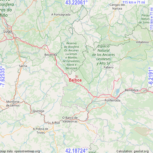
Balboa GPS coordinates[2]
42° 42' 21.888" North, 6° 55' 19.992" West
| Map corner | latitude | longitude |
|---|---|---|
| Upper-left | 43.22061°, | -7.62535° |
| Center: | 42.70608°, | -6.92222° |
| Lower-right: | 42.18724°, | -6.2191° |
| Map W x H: | 114.9×114.9 km | = 71.4×71.4mi |
| max Lat: | 43.74134° ⇑8.4% North |
| Balboa: | 42.70608° |
| min Lat: | ⇓91.6% South 27.64134° |
| min Long | Balboa | max Long |
| -18.00367° | -6.92222° | 4.2899° |
| W 6%⇐ | ⇒94% E |
Elevation
Elevation of Balboa is 693 m = 2274 ft, and this is 95 m = 312 ft above average elevation for this country.
| Max E: |
1682 m = 5518 ft | 46.8% |
| Balboa | 693 m 2274 ft | |
| Avg. | 598 m = 1962 ft | |
Min E: |
0 m = 0 ft | 53.2% |
See also: Spain elevation on elevation.city.
Geographical zone
Balboa is located in North temperate zone (between Tropic of Cancer and the Arctic Circle). Distance of this Northern Tropic circle is 2142.6 km =1331.3 mi to South.| Distance of | km | miles | from Balboa |
|---|---|---|---|
| North Pole | 5258.6 | 3267.5 | to North |
| Arctic Circle | 2652.7 | 1648.3 | to North |
| Tropic Cancer | 2142.6 | 1331.3 | to South |
| Equator | 4748.5 | 2950.6 | to South |


Nearby cities:
15 places around Balboa: (largest is in red/bold)
• Arganza
20.6 km =12.8 mi,  110°
110°
• Barjas
11.5 km =7.1 mi,  204°
204°
• Cacabelos
20.1 km =12.5 mi,  125°
125°
• Candín
20.1 km =12.5 mi,  52°
52°
• Carracedelo
22.8 km =14.2 mi,  137°
137°
• Corullón
16.5 km =10.3 mi,  149°
149°
• Oencia
18 km =11.2 mi,  192°
192°
• San Román
21.5 km =13.4 mi,  327°
327°
• Sancedo
23.9 km =14.9 mi,  100°
100°
• Sobrado
21.9 km =13.6 mi,  164°
164°
• Trabadelo
7.2 km =4.5 mi, 151°
• Vega de Espinareda
22 km =13.7 mi,  84°
84°
• Vega de Valcarce
5.2 km =3.2 mi, 194°
• Villadecanes
19.3 km =12 mi, 136°
• Villafranca del Bierzo
14.4 km =8.9 mi, 140°
Sources, notices
• [Note1] Compared only with cities in Spain existing in our database
• [Src1] Map data: © OpenStreetMap contributors (CC-BY-SA)
• [Src2] Other city data from geonames.org with taken over terms of usage.
• [Src3] Geographical zone / Annual Mean Temperature by Robert A. Rohde @ Wikipedia
