San Morales geodata
San Morales (Castille and León) is a seat of a third-order administrative division; located in Spain in Europe/Madrid (GMT+2) time zone. With population of 238 people, there are 4817 cities with bigger population in this country. Compared to other cities in Spain, 51.8% of cities are located further ↑North; 78.8% of cities are located further →East and 67.5% of cities have lower elevation than San Morales. Note1
Administrative division(s):
- Level 1: Castille and León
- Level 2: Provincia de Salamanca
- Level 3: San Morales


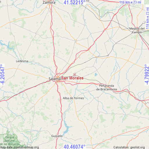
San Morales GPS coordinates[2]
40° 59' 36.888" North, 5° 30' 8.424" West
| Map corner | latitude | longitude |
|---|---|---|
| Upper-left | 41.52215°, | -6.20547° |
| Center: | 40.99358°, | -5.50234° |
| Lower-right: | 40.46074°, | -4.79922° |
| Map W x H: | 118×118 km | = 73.3×73.3mi |
| max Lat: | 43.74134° ⇑51.8% North |
| San Morales: | 40.99358° |
| min Lat: | ⇓48.2% South 27.64134° |
| min Long | San Morales | max Long |
| -18.00367° | -5.50234° | 4.2899° |
| W 21.2%⇐ | ⇒78.8% E |
Elevation
Elevation of San Morales is 795 m = 2608 ft, and this is 197 m = 646 ft above average elevation for this country.
| Max E: |
1682 m = 5518 ft | 32.5% |
| San Morales | 795 m 2608 ft | |
| Avg. | 598 m = 1962 ft | |
Min E: |
0 m = 0 ft | 67.5% |
See also: Spain elevation on elevation.city.
Geographical zone
San Morales is located in North temperate zone (between Tropic of Cancer and the Arctic Circle). Distance of this Northern Tropic circle is 1952.1 km =1213 mi to South.| Distance of | km | miles | from San Morales |
|---|---|---|---|
| North Pole | 5449 | 3385.9 | to North |
| Arctic Circle | 2843.1 | 1766.6 | to North |
| Tropic Cancer | 1952.1 | 1213 | to South |
| Equator | 4558.1 | 2832.3 | to South |


Nearby cities:
15 places around San Morales: (largest is in red/bold)
• Aldealengua
4.2 km =2.6 mi,  250°
250°
• Aldearrubia
1.6 km =1 mi,  11°
11°
• Babilafuente
6.7 km =4.2 mi,  105°
105°
• Cabezabellosa de la Calzada
5.7 km =3.5 mi, 11°
• Calvarrasa de Abajo
6.7 km =4.2 mi,  218°
218°
• Castellanos de Moriscos
7.9 km =4.9 mi,  291°
291°
• Encinas de Abajo
7.1 km =4.4 mi,  157°
157°
• Gomecello
6.2 km =3.9 mi,  332°
332°
• Huerta
4 km =2.5 mi,  133°
133°
• Machacón
7.7 km =4.8 mi,  193°
193°
• Moriscos
6.9 km =4.3 mi,  283°
283°
• Pedrosillo el Ralo
8.6 km =5.3 mi, 333°
• Pelabravo
9 km =5.6 mi,  225°
225°
• Pitiegua
8.2 km =5.1 mi,  21°
21°
• Villaverde de Guareña
8.1 km =5 mi,  346°
346°
Sources, notices
• [Note1] Compared only with cities in Spain existing in our database
• [Src1] Map data: © OpenStreetMap contributors (CC-BY-SA)
• [Src2] Other city data from geonames.org with taken over terms of usage.
• [Src3] Geographical zone / Annual Mean Temperature by Robert A. Rohde @ Wikipedia
