Aldearrubia geodata
Aldearrubia (Castille and León) is a seat of a third-order administrative division; located in Spain in Europe/Madrid (GMT+2) time zone. With population of 509 people, there are 3858 cities with bigger population in this country. Compared to other cities in Spain, 51.4% of cities are located further ↑North; 78.7% of cities are located further →East and 70% of cities have lower elevation than Aldearrubia. Note1
Administrative division(s):
- Level 1: Castille and León
- Level 2: Provincia de Salamanca
- Level 3: Aldearrubia


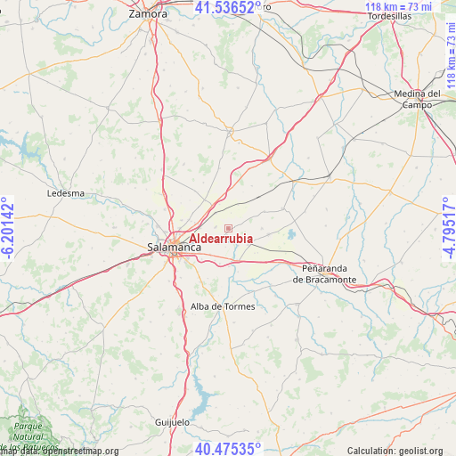
Aldearrubia GPS coordinates[2]
41° 0' 29.052" North, 5° 29' 53.844" West
| Map corner | latitude | longitude |
|---|---|---|
| Upper-left | 41.53652°, | -6.20142° |
| Center: | 41.00807°, | -5.49829° |
| Lower-right: | 40.47535°, | -4.79517° |
| Map W x H: | 118×118 km | = 73.3×73.3mi |
| max Lat: | 43.74134° ⇑51.4% North |
| Aldearrubia: | 41.00807° |
| min Lat: | ⇓48.6% South 27.64134° |
| min Long | Aldearrubia | max Long |
| -18.00367° | -5.49829° | 4.2899° |
| W 21.3%⇐ | ⇒78.7% E |
Elevation
Elevation of Aldearrubia is 814 m = 2671 ft, and this is 216 m = 709 ft above average elevation for this country.
| Max E: |
1682 m = 5518 ft | 30% |
| Aldearrubia | 814 m 2671 ft | |
| Avg. | 598 m = 1962 ft | |
Min E: |
0 m = 0 ft | 70% |
See also: Spain elevation on elevation.city.
Geographical zone
Aldearrubia is located in North temperate zone (between Tropic of Cancer and the Arctic Circle). Distance of this Northern Tropic circle is 1953.8 km =1214 mi to South.| Distance of | km | miles | from Aldearrubia |
|---|---|---|---|
| North Pole | 5447.4 | 3384.9 | to North |
| Arctic Circle | 2841.5 | 1765.6 | to North |
| Tropic Cancer | 1953.8 | 1214 | to South |
| Equator | 4559.7 | 2833.3 | to South |


Nearby cities:
15 places around Aldearrubia: (largest is in red/bold)
• Aldealengua
5.2 km =3.2 mi,  234°
234°
• Babilafuente
7 km =4.3 mi,  119°
119°
• Cabezabellosa de la Calzada
4.1 km =2.5 mi,  11°
11°
• Calvarrasa de Abajo
8.2 km =5.1 mi,  213°
213°
• Castellanos de Moriscos
7.8 km =4.8 mi,  279°
279°
• Encinas de Abajo
8.5 km =5.3 mi,  163°
163°
• Gomecello
5 km =3.1 mi,  320°
320°
• Huerta
5.1 km =3.2 mi,  149°
149°
• Moriscos
7 km =4.3 mi,  270°
270°
• Pajares de la Laguna
8.9 km =5.5 mi,  354°
354°
• Pedrosillo el Ralo
7.4 km =4.6 mi,  325°
325°
• Pitiegua
6.6 km =4.1 mi,  23°
23°
• San Morales
1.6 km =1 mi,  191°
191°
• Villaverde de Guareña
6.6 km =4.1 mi,  340°
340°
• Villoruela
8.8 km =5.5 mi,  89°
89°
Sources, notices
• [Note1] Compared only with cities in Spain existing in our database
• [Src1] Map data: © OpenStreetMap contributors (CC-BY-SA)
• [Src2] Other city data from geonames.org with taken over terms of usage.
• [Src3] Geographical zone / Annual Mean Temperature by Robert A. Rohde @ Wikipedia
