Machacón geodata
Machacón (Castille and León) is a seat of a third-order administrative division; located in Spain in Europe/Madrid (GMT+2) time zone. With population of 517 people, there are 3825 cities with bigger population in this country. Compared to other cities in Spain, 53.3% of cities are located further ↑North; 79% of cities are located further →East and 69.3% of cities have lower elevation than Machacón. Note1
Administrative division(s):
- Level 1: Castille and León
- Level 2: Provincia de Salamanca
- Level 3: Machacón


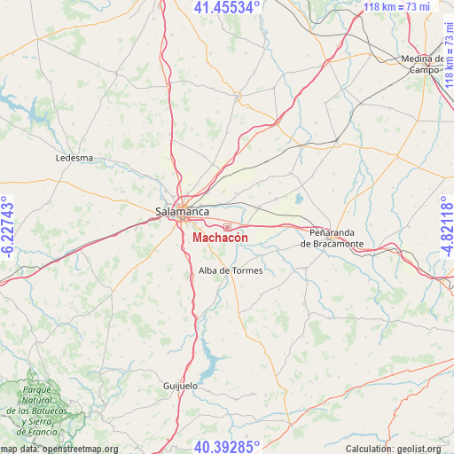
Machacón GPS coordinates[2]
40° 55' 34.428" North, 5° 31' 27.48" West
| Map corner | latitude | longitude |
|---|---|---|
| Upper-left | 41.45534°, | -6.22743° |
| Center: | 40.92623°, | -5.5243° |
| Lower-right: | 40.39285°, | -4.82118° |
| Map W x H: | 118.1×118.1 km | = 73.4×73.4mi |
| max Lat: | 43.74134° ⇑53.3% North |
| Machacón: | 40.92623° |
| min Lat: | ⇓46.7% South 27.64134° |
| min Long | Machacón | max Long |
| -18.00367° | -5.5243° | 4.2899° |
| W 21%⇐ | ⇒79% E |
Elevation
Elevation of Machacón is 808 m = 2651 ft, and this is 210 m = 689 ft above average elevation for this country.
| Max E: |
1682 m = 5518 ft | 30.7% |
| Machacón | 808 m 2651 ft | |
| Avg. | 598 m = 1962 ft | |
Min E: |
0 m = 0 ft | 69.3% |
See also: Spain elevation on elevation.city.
Geographical zone
Machacón is located in North temperate zone (between Tropic of Cancer and the Arctic Circle). Distance of this Northern Tropic circle is 1944.7 km =1208.4 mi to South.| Distance of | km | miles | from Machacón |
|---|---|---|---|
| North Pole | 5456.5 | 3390.5 | to North |
| Arctic Circle | 2850.6 | 1771.3 | to North |
| Tropic Cancer | 1944.7 | 1208.4 | to South |
| Equator | 4550.6 | 2827.6 | to South |


Nearby cities:
15 places around Machacón: (largest is in red/bold)
• Aldealengua
6.4 km =4 mi,  341°
341°
• Aldearrubia
9.4 km =5.8 mi,  13°
13°
• Babilafuente
10 km =6.2 mi,  55°
55°
• Cabrerizos
9.2 km =5.7 mi,  309°
309°
• Calvarrasa de Abajo
3.3 km =2.1 mi, 313°
• Calvarrasa de Arriba
6.1 km =3.8 mi,  249°
249°
• Cordovilla
10.2 km =6.3 mi,  74°
74°
• Encinas de Abajo
4.6 km =2.9 mi,  77°
77°
• Huerta
6.7 km =4.2 mi,  45°
45°
• Moriscos
10.3 km =6.4 mi,  332°
332°
• Pelabravo
4.7 km =2.9 mi,  284°
284°
• San Morales
7.7 km =4.8 mi, 13°
• Santa Marta de Tormes
9.1 km =5.7 mi,  287°
287°
• Terradillos
9.9 km =6.2 mi,  188°
188°
• Villagonzalo de Tormes
4.4 km =2.7 mi,  148°
148°
Sources, notices
• [Note1] Compared only with cities in Spain existing in our database
• [Src1] Map data: © OpenStreetMap contributors (CC-BY-SA)
• [Src2] Other city data from geonames.org with taken over terms of usage.
• [Src3] Geographical zone / Annual Mean Temperature by Robert A. Rohde @ Wikipedia
