Santander geodata
Santander (Cantabria) is a seat of a first-order administrative division; located in Spain in Europe/Madrid (GMT+2) time zone. With population of 182,700 people, there are 42 cities with bigger population in this country. Compared to other cities in Spain, 99.3% of cities are located further ↓South; 56.8% of cities are located further →East and 94.4% of cities have higher elevation than Santander. Note1


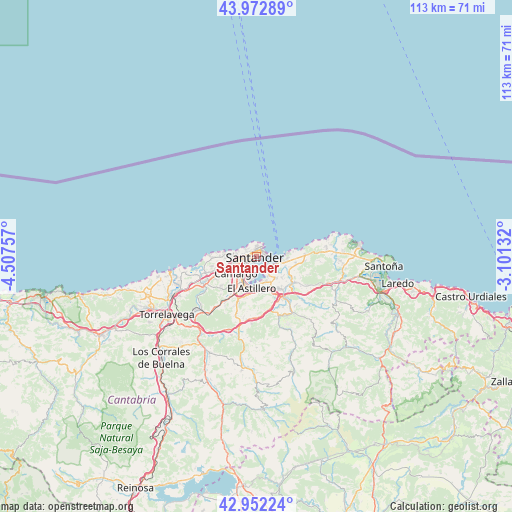
Santander GPS coordinates[2]
43° 27' 52.992" North, 3° 48' 15.984" West
| Map corner | latitude | longitude |
|---|---|---|
| Upper-left | 43.97289°, | -4.50757° |
| Center: | 43.46472°, | -3.80444° |
| Lower-right: | 42.95224°, | -3.10132° |
| Map W x H: | 113.5×113.5 km | = 70.5×70.5mi |
| max Lat: | 43.74134° ⇑0.7% North |
| Santander: | 43.46472° |
| min Lat: | ⇓99.3% South 27.64134° |
| min Long | Santander | max Long |
| -18.00367° | -3.80444° | 4.2899° |
| W 43.2%⇐ | ⇒56.8% E |
Elevation
Elevation of Santander is 28 m = 92 ft, and this is 570 m = 1870 ft below average elevation for this country.
| Max E: |
1682 m = 5518 ft | 94.4% |
| Avg. | 598 m = 1962 ft | |
| Santander | 28 m = 92 ft | |
Min E: |
0 m = 0 ft | 5.6% |
See also: Santander elevation on elevation.city.
Geographical zone
Santander is located in North temperate zone (between Tropic of Cancer and the Arctic Circle). Distance of this Northern Tropic circle is 2226.9 km =1383.7 mi to South.| Distance of | km | miles | from Santander |
|---|---|---|---|
| North Pole | 5174.2 | 3215.1 | to North |
| Arctic Circle | 2568.4 | 1595.9 | to North |
| Tropic Cancer | 2226.9 | 1383.7 | to South |
| Equator | 4832.8 | 3003 | to South |


Nearby cities:
15 places around Santander: (largest is in red/bold)
• Arnuero
19 km =11.8 mi,  85°
85°
• Bareyo
16.4 km =10.2 mi, 89°
• Camargo
9.1 km =5.7 mi,  225°
225°
• El Astillero
7.2 km =4.5 mi,  190°
190°
• Entrambasaguas
13.8 km =8.6 mi,  133°
133°
• Hazas de Cesto
19 km =11.8 mi,  113°
113°
• Liérganes
14 km =8.7 mi,  160°
160°
• Miengo
16.2 km =10.1 mi,  255°
255°
• Penagos
12.5 km =7.8 mi,  183°
183°
• Polanco
19.3 km =12 mi,  242°
242°
• San Miguel de Meruelo
17.4 km =10.8 mi, 90°
• Santa Cruz de Bezana
8.3 km =5.2 mi,  253°
253°
• Santa María de Cayón
17.6 km =10.9 mi, 188°
• Suances
19.6 km =12.2 mi, 259°
• Villanueva de Villaescusa
11.8 km =7.3 mi,  203°
203°
Sources, notices
• [Note1] Compared only with cities in Spain existing in our database
• [Src1] Map data: © OpenStreetMap contributors (CC-BY-SA)
• [Src2] Other city data from geonames.org with taken over terms of usage.
• [Src3] Geographical zone / Annual Mean Temperature by Robert A. Rohde @ Wikipedia
