San Cristóbal de Entreviñas geodata
San Cristóbal de Entreviñas (Castille and León) is a seat of a third-order administrative division; located in Spain in Europe/Madrid (GMT+2) time zone. With population of 1,642 people, there are 2377 cities with bigger population in this country. Compared to other cities in Spain, 74.9% of cities are located further ↓South; 80.6% of cities are located further →East and 56% of cities have lower elevation than San Cristóbal de Entreviñas. Note1
Administrative division(s):
- Level 1: Castille and León
- Level 2: Provincia de Zamora
- Level 3: San Cristóbal de Entreviñas
Current local time in San Cristóbal de Entreviñas:
12:19 AM, FridayDifference from your time zone: hours


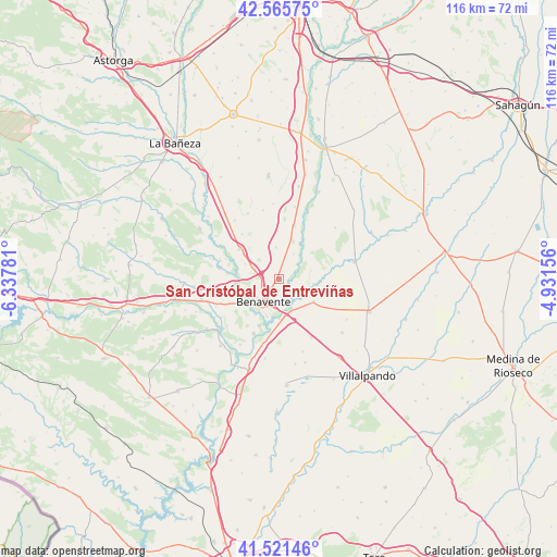
San Cristóbal de Entreviñas GPS coordinates[2]
42° 2' 44.7" North, 5° 38' 4.848" West
| Map corner | latitude | longitude |
|---|---|---|
| Upper-left | 42.56575°, | -6.33781° |
| Center: | 42.04575°, | -5.63468° |
| Lower-right: | 41.52146°, | -4.93156° |
| Map W x H: | 116.1×116.1 km | = 72.1×72.1mi |
| max Lat: | 43.74134° ⇑25.1% North |
| San Cristóbal de Entreviñas: | 42.04575° |
| min Lat: | ⇓74.9% South 27.64134° |
| min Long | San Cristóbal | max Long |
| -18.00367° | -5.63468° | 4.2899° |
| W 19.4%⇐ | ⇒80.6% E |
Elevation
Elevation of San Cristóbal de Entreviñas is 716 m = 2349 ft, and this is 118 m = 387 ft above average elevation for this country.
| Max E: |
1682 m = 5518 ft | 44% |
| San Cristóbal de Entreviñas | 716 m 2349 ft | |
| Avg. | 598 m = 1962 ft | |
Min E: |
0 m = 0 ft | 56% |
See also: Spain elevation on elevation.city.
Geographical zone
San Cristóbal de Entreviñas is located in North temperate zone (between Tropic of Cancer and the Arctic Circle). Distance of this Northern Tropic circle is 2069.1 km =1285.7 mi to South.| Distance of | km | miles | from San Cristóbal de Entreviñas |
|---|---|---|---|
| North Pole | 5332 | 3313.2 | to North |
| Arctic Circle | 2726.1 | 1693.9 | to North |
| Tropic Cancer | 2069.1 | 1285.7 | to South |
| Equator | 4675 | 2904.9 | to South |


Nearby cities:
15 places around San Cristóbal de Entreviñas: (largest is in red/bold)
• Benavente
6 km =3.7 mi,  216°
216°
• Castrogonzalo
6.6 km =4.1 mi,  156°
156°
• Cimanes de la Vega
8.4 km =5.2 mi,  20°
20°
• Fresno de la Polvorosa
11.9 km =7.4 mi,  290°
290°
• Fuentes de Ropel
8.7 km =5.4 mi,  122°
122°
• Manganeses de la Polvorosa
9.3 km =5.8 mi,  263°
263°
• Matilla de Arzón
6.6 km =4.1 mi,  355°
355°
• Pobladura del Valle
10.3 km =6.4 mi,  307°
307°
• San Adrián del Valle
12.2 km =7.6 mi,  320°
320°
• Santa Colomba de las Monjas
10.5 km =6.5 mi,  202°
202°
• Santa Cristina de la Polvorosa
8.3 km =5.2 mi,  231°
231°
• Valdescorriel
10.6 km =6.6 mi,  104°
104°
• Villabrázaro
7.7 km =4.8 mi,  276°
276°
• Villanueva de Azoague
8.1 km =5 mi, 197°
• Villaquejida
11.5 km =7.1 mi, 15°
Sources, notices
• [Note1] Compared only with cities in Spain existing in our database
• [Src1] Map data: © OpenStreetMap contributors (CC-BY-SA)
• [Src2] Other city data from geonames.org with taken over terms of usage.
• [Src3] Geographical zone / Annual Mean Temperature by Robert A. Rohde @ Wikipedia
