Sant Andreu Salou geodata
Sant Andreu Salou (Catalonia) is a seat of a third-order administrative division; located in Spain in Europe/Madrid (GMT+2) time zone. In our database, there are 6762 cities with bigger population. Compared to other cities in Spain, 70.2% of cities are located further ↓South; 97.7% of cities are located further ←West and 86.8% of cities have higher elevation than Sant Andreu Salou. Note1
Administrative division(s):
- Level 1: Catalonia
- Level 2: Província de Girona
- Level 3: Sant Andreu Salou


Sant Andreu Salou GPS coordinates[2]
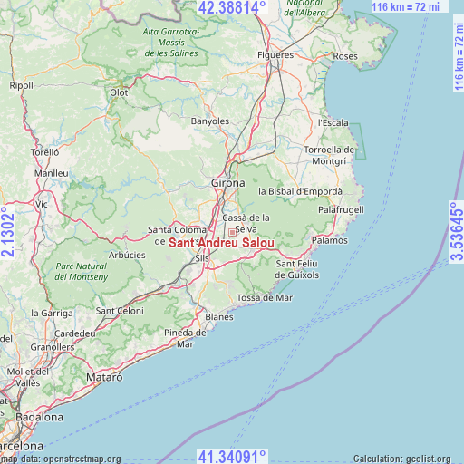
41° 52' 0.012" North, 2° 49' 59.988" East
| Map corner | latitude | longitude |
|---|---|---|
| Upper-left | 42.38814°, | 2.1302° |
| Center: | 41.86667°, | 2.83333° |
| Lower-right: | 41.34091°, | 3.53645° |
| Map W x H: | 116.4×116.4 km | = 72.3×72.3mi |
| max Lat: | 43.74134° ⇑29.8% North |
| Sant Andreu Salou: | 41.86667° |
| min Lat: | ⇓70.2% South 27.64134° |
| min Long | Sant Andreu Sal | max Long |
| -18.00367° | 2.83333° | 4.2899° |
| W 97.7%⇐ | ⇒2.3% E |
Elevation
Elevation of Sant Andreu Salou is 112 m = 367 ft, and this is 486 m = 1594 ft below average elevation for this country.
| Max E: |
1682 m = 5518 ft | 86.8% |
| Avg. | 598 m = 1962 ft | |
| Sant Andreu Salou | 112 m = 367 ft | |
Min E: |
0 m = 0 ft | 13.2% |
See also: Spain elevation on elevation.city.
Geographical zone
Sant Andreu Salou is located in North temperate zone (between Tropic of Cancer and the Arctic Circle). Distance of this Northern Tropic circle is 2049.2 km =1273.3 mi to South.| Distance of | km | miles | from Sant Andreu Salou |
|---|---|---|---|
| North Pole | 5351.9 | 3325.5 | to North |
| Arctic Circle | 2746 | 1706.3 | to North |
| Tropic Cancer | 2049.2 | 1273.3 | to South |
| Equator | 4655.1 | 2892.5 | to South |


Nearby cities:
15 places around Sant Andreu Salou: (largest is in red/bold)
• Aiguaviva
9.9 km =6.2 mi,  323°
323°
• Caldes de Malavella
4 km =2.5 mi,  200°
200°
• Cassà de la Selva
4.2 km =2.6 mi,  55°
55°
• Fornells de la Selva
7.5 km =4.7 mi,  344°
344°
• Llagostera
6.7 km =4.2 mi,  131°
131°
• Llambilles
6.2 km =3.9 mi,  13°
13°
• Maçanet de la Selva
12.4 km =7.7 mi,  221°
221°
• Quart d’Onyar
8.2 km =5.1 mi,  4°
4°
• Riudarenes
11.1 km =6.9 mi,  240°
240°
• Riudellots de la Selva
3.8 km =2.4 mi, 321°
• Salt
12.5 km =7.8 mi, 344°
• Sils
9.8 km =6.1 mi,  228°
228°
• Vidreres
10.2 km =6.3 mi, 204°
• Vilablareix
11.2 km =7 mi,  333°
333°
• Vilobí d'Onyar
7.1 km =4.4 mi,  285°
285°
Sources, notices
• [Note1] Compared only with cities in Spain existing in our database
• [Src1] Map data: © OpenStreetMap contributors (CC-BY-SA)
• [Src2] Other city data from geonames.org with taken over terms of usage.
• [Src3] Geographical zone / Annual Mean Temperature by Robert A. Rohde @ Wikipedia
