Llagostera geodata
Llagostera (Catalonia) is a seat of a third-order administrative division; located in Spain in Europe/Madrid (GMT+2) time zone. With population of 6,713 people, there are 1066 cities with bigger population in this country. Compared to other cities in Spain, 69.3% of cities are located further ↓South; 98.1% of cities are located further ←West and 85.1% of cities have higher elevation than Llagostera. Note1


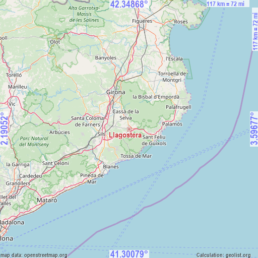
Llagostera GPS coordinates[2]
41° 49' 36.768" North, 2° 53' 37.14" East
| Map corner | latitude | longitude |
|---|---|---|
| Upper-left | 42.34868°, | 2.19052° |
| Center: | 41.82688°, | 2.89365° |
| Lower-right: | 41.30079°, | 3.59677° |
| Map W x H: | 116.5×116.5 km | = 72.4×72.4mi |
| max Lat: | 43.74134° ⇑30.7% North |
| Llagostera: | 41.82688° |
| min Lat: | ⇓69.3% South 27.64134° |
| min Long | Llagostera | max Long |
| -18.00367° | 2.89365° | 4.2899° |
| W 98.1%⇐ | ⇒1.9% E |
Elevation
Elevation of Llagostera is 136 m = 446 ft, and this is 462 m = 1516 ft below average elevation for this country.
| Max E: |
1682 m = 5518 ft | 85.1% |
| Avg. | 598 m = 1962 ft | |
| Llagostera | 136 m = 446 ft | |
Min E: |
0 m = 0 ft | 14.9% |
See also: Spain elevation on elevation.city.
Geographical zone
Llagostera is located in North temperate zone (between Tropic of Cancer and the Arctic Circle). Distance of this Northern Tropic circle is 2044.8 km =1270.6 mi to South.| Distance of | km | miles | from Llagostera |
|---|---|---|---|
| North Pole | 5356.3 | 3328.2 | to North |
| Arctic Circle | 2750.5 | 1709.1 | to North |
| Tropic Cancer | 2044.8 | 1270.6 | to South |
| Equator | 4650.7 | 2889.8 | to South |


Nearby cities:
15 places around Llagostera: (largest is in red/bold)
• Caldes de Malavella
6.4 km =4 mi,  276°
276°
• Cassà de la Selva
6.9 km =4.3 mi,  347°
347°
• Fornells de la Selva
13.6 km =8.5 mi,  328°
328°
• Llambilles
11.1 km =6.9 mi,  341°
341°
• Maçanet de la Selva
14.1 km =8.8 mi,  249°
249°
• Quart d’Onyar
13.4 km =8.3 mi, 340°
• Riudellots de la Selva
10.4 km =6.5 mi,  315°
315°
• S'Agaró
13.8 km =8.6 mi,  105°
105°
• Sant Andreu Salou
6.7 km =4.2 mi,  311°
311°
• Sant Feliu de Guíxols
12.5 km =7.8 mi, 112°
• Santa Cristina d'Aro
8.9 km =5.5 mi,  97°
97°
• Sils
12.5 km =7.8 mi,  260°
260°
• Tossa de Mar
12.7 km =7.9 mi,  164°
164°
• Vidreres
10.3 km =6.4 mi,  242°
242°
• Vilobí d'Onyar
13.5 km =8.4 mi,  297°
297°
Sources, notices
• [Note1] Compared only with cities in Spain existing in our database
• [Src1] Map data: © OpenStreetMap contributors (CC-BY-SA)
• [Src2] Other city data from geonames.org with taken over terms of usage.
• [Src3] Geographical zone / Annual Mean Temperature by Robert A. Rohde @ Wikipedia
