Salmoral geodata
Salmoral (Castille and León) is a seat of a third-order administrative division; located in Spain in Europe/Madrid (GMT+2) time zone. With population of 257 people, there are 4702 cities with bigger population in this country. Compared to other cities in Spain, 56.1% of cities are located further ↑North; 75.4% of cities are located further →East and 81.4% of cities have lower elevation than Salmoral. Note1
Administrative division(s):
- Level 1: Castille and León
- Level 2: Provincia de Salamanca
- Level 3: Salmoral


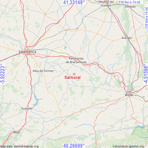
Salmoral GPS coordinates[2]
40° 48' 4.932" North, 5° 13' 8.76" West
| Map corner | latitude | longitude |
|---|---|---|
| Upper-left | 41.33149°, | -5.92223° |
| Center: | 40.80137°, | -5.2191° |
| Lower-right: | 40.26699°, | -4.51598° |
| Map W x H: | 118.4×118.4 km | = 73.6×73.6mi |
| max Lat: | 43.74134° ⇑56.1% North |
| Salmoral: | 40.80137° |
| min Lat: | ⇓43.9% South 27.64134° |
| min Long | Salmoral | max Long |
| -18.00367° | -5.2191° | 4.2899° |
| W 24.6%⇐ | ⇒75.4% E |
Elevation
Elevation of Salmoral is 911 m = 2989 ft, and this is 313 m = 1027 ft above average elevation for this country.
| Max E: |
1682 m = 5518 ft | 18.6% |
| Salmoral | 911 m 2989 ft | |
| Avg. | 598 m = 1962 ft | |
Min E: |
0 m = 0 ft | 81.4% |
See also: Spain elevation on elevation.city.
Geographical zone
Salmoral is located in North temperate zone (between Tropic of Cancer and the Arctic Circle). Distance of this Northern Tropic circle is 1930.8 km =1199.7 mi to South.| Distance of | km | miles | from Salmoral |
|---|---|---|---|
| North Pole | 5470.4 | 3399.1 | to North |
| Arctic Circle | 2864.5 | 1779.9 | to North |
| Tropic Cancer | 1930.8 | 1199.7 | to South |
| Equator | 4536.7 | 2819 | to South |


Nearby cities:
15 places around Salmoral: (largest is in red/bold)
• Alaraz
8.2 km =5.1 mi,  224°
224°
• Blascomillán
11.1 km =6.9 mi,  89°
89°
• Bóveda del Río Almar
6.3 km =3.9 mi,  6°
6°
• Cabezas del Villar
9.6 km =6 mi,  175°
175°
• Cantaracillo
12.3 km =7.6 mi,  22°
22°
• Gajates
12.5 km =7.8 mi,  260°
260°
• Gimialcón
11.7 km =7.3 mi,  43°
43°
• Macotera
6.5 km =4 mi,  300°
300°
• Malpartida
4.4 km =2.7 mi,  193°
193°
• Mancera de Abajo
4.6 km =2.9 mi, 21°
• Mancera de Arriba
6.1 km =3.8 mi,  100°
100°
• Nava de Sotrobal
11.4 km =7.1 mi,  330°
330°
• Peñaranda de Bracamonte
11.2 km =7 mi, 8°
• San García de Ingelmos
9.5 km =5.9 mi,  112°
112°
• Santiago de la Puebla
5.2 km =3.2 mi,  269°
269°
Sources, notices
• [Note1] Compared only with cities in Spain existing in our database
• [Src1] Map data: © OpenStreetMap contributors (CC-BY-SA)
• [Src2] Other city data from geonames.org with taken over terms of usage.
• [Src3] Geographical zone / Annual Mean Temperature by Robert A. Rohde @ Wikipedia
