Macotera geodata
Macotera (Castille and León) is a seat of a third-order administrative division; located in Spain in Europe/Madrid (GMT+2) time zone. With population of 1,525 people, there are 2446 cities with bigger population in this country. Compared to other cities in Spain, 55.4% of cities are located further ↑North; 76.2% of cities are located further →East and 79.7% of cities have lower elevation than Macotera. Note1
Administrative division(s):
- Level 1: Castille and León
- Level 2: Provincia de Salamanca
- Level 3: Macotera


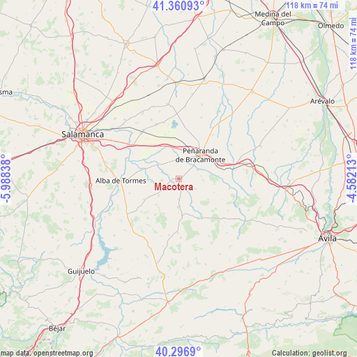
Macotera GPS coordinates[2]
40° 49' 51.78" North, 5° 17' 6.936" West
| Map corner | latitude | longitude |
|---|---|---|
| Upper-left | 41.36093°, | -5.98838° |
| Center: | 40.83105°, | -5.28526° |
| Lower-right: | 40.2969°, | -4.58213° |
| Map W x H: | 118.3×118.3 km | = 73.5×73.5mi |
| max Lat: | 43.74134° ⇑55.4% North |
| Macotera: | 40.83105° |
| min Lat: | ⇓44.6% South 27.64134° |
| min Long | Macotera | max Long |
| -18.00367° | -5.28526° | 4.2899° |
| W 23.8%⇐ | ⇒76.2% E |
Elevation
Elevation of Macotera is 894 m = 2933 ft, and this is 296 m = 971 ft above average elevation for this country.
| Max E: |
1682 m = 5518 ft | 20.3% |
| Macotera | 894 m 2933 ft | |
| Avg. | 598 m = 1962 ft | |
Min E: |
0 m = 0 ft | 79.7% |
See also: Spain elevation on elevation.city.
Geographical zone
Macotera is located in North temperate zone (between Tropic of Cancer and the Arctic Circle). Distance of this Northern Tropic circle is 1934.1 km =1201.8 mi to South.| Distance of | km | miles | from Macotera |
|---|---|---|---|
| North Pole | 5467.1 | 3397.1 | to North |
| Arctic Circle | 2861.2 | 1777.9 | to North |
| Tropic Cancer | 1934.1 | 1201.8 | to South |
| Equator | 4540 | 2821 | to South |


Nearby cities:
15 places around Macotera: (largest is in red/bold)
• Alaraz
9.1 km =5.7 mi,  181°
181°
• Alconada
11 km =6.8 mi,  323°
323°
• Bóveda del Río Almar
6.9 km =4.3 mi,  65°
65°
• Coca de Alba
8.5 km =5.3 mi,  307°
307°
• Gajates
8.6 km =5.3 mi,  231°
231°
• Malpartida
8.8 km =5.5 mi,  149°
149°
• Mancera de Abajo
7.3 km =4.5 mi,  82°
82°
• Nava de Sotrobal
6.6 km =4.1 mi,  359°
359°
• Pedraza de Alba
11.4 km =7.1 mi,  221°
221°
• Pedrosillo de Alba
9.3 km =5.8 mi,  264°
264°
• Peñaranda de Bracamonte
10.6 km =6.6 mi,  42°
42°
• Peñarandilla
10.8 km =6.7 mi,  302°
302°
• Salmoral
6.5 km =4 mi,  120°
120°
• Santiago de la Puebla
3.3 km =2.1 mi,  173°
173°
• Tordillos
6.2 km =3.9 mi,  292°
292°
Sources, notices
• [Note1] Compared only with cities in Spain existing in our database
• [Src1] Map data: © OpenStreetMap contributors (CC-BY-SA)
• [Src2] Other city data from geonames.org with taken over terms of usage.
• [Src3] Geographical zone / Annual Mean Temperature by Robert A. Rohde @ Wikipedia
