Cantaracillo geodata
Cantaracillo (Castille and León) is a seat of a third-order administrative division; located in Spain in Europe/Madrid (GMT+2) time zone. With population of 245 people, there are 4773 cities with bigger population in this country. Compared to other cities in Spain, 53.8% of cities are located further ↑North; 74.6% of cities are located further →East and 81.5% of cities have lower elevation than Cantaracillo. Note1
Administrative division(s):
- Level 1: Castille and León
- Level 2: Provincia de Salamanca
- Level 3: Cantaracillo


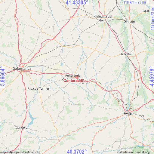
Cantaracillo GPS coordinates[2]
40° 54' 13.536" North, 5° 9' 46.476" West
| Map corner | latitude | longitude |
|---|---|---|
| Upper-left | 41.43305°, | -5.86604° |
| Center: | 40.90376°, | -5.16291° |
| Lower-right: | 40.3702°, | -4.45979° |
| Map W x H: | 118.2×118.2 km | = 73.4×73.4mi |
| max Lat: | 43.74134° ⇑53.8% North |
| Cantaracillo: | 40.90376° |
| min Lat: | ⇓46.2% South 27.64134° |
| min Long | Cantaracillo | max Long |
| -18.00367° | -5.16291° | 4.2899° |
| W 25.4%⇐ | ⇒74.6% E |
Elevation
Elevation of Cantaracillo is 912 m = 2992 ft, and this is 314 m = 1030 ft above average elevation for this country.
| Max E: |
1682 m = 5518 ft | 18.5% |
| Cantaracillo | 912 m 2992 ft | |
| Avg. | 598 m = 1962 ft | |
Min E: |
0 m = 0 ft | 81.5% |
See also: Spain elevation on elevation.city.
Geographical zone
Cantaracillo is located in North temperate zone (between Tropic of Cancer and the Arctic Circle). Distance of this Northern Tropic circle is 1942.2 km =1206.8 mi to South.| Distance of | km | miles | from Cantaracillo |
|---|---|---|---|
| North Pole | 5459 | 3392.1 | to North |
| Arctic Circle | 2853.1 | 1772.8 | to North |
| Tropic Cancer | 1942.2 | 1206.8 | to South |
| Equator | 4548.1 | 2826.1 | to South |


Nearby cities:
15 places around Cantaracillo: (largest is in red/bold)
• Aldeaseca de la Frontera
5.6 km =3.5 mi,  318°
318°
• Bóveda del Río Almar
6.5 km =4 mi,  217°
217°
• Flores de Ávila
7.8 km =4.8 mi,  64°
64°
• Gimialcón
4.5 km =2.8 mi,  131°
131°
• Mancera de Abajo
7.7 km =4.8 mi,  203°
203°
• Mancera de Arriba
12.6 km =7.8 mi,  174°
174°
• Muñosancho
10.9 km =6.8 mi,  79°
79°
• Narros del Castillo
10 km =6.2 mi,  120°
120°
• Nava de Sotrobal
10.4 km =6.5 mi,  261°
261°
• Paradinas de San Juan
8.9 km =5.5 mi,  4°
4°
• Peñaranda de Bracamonte
3.2 km =2 mi, 264°
• Rágama
10.9 km =6.8 mi,  16°
16°
• Salmoral
12.3 km =7.6 mi, 202°
• Salvadiós
6.3 km =3.9 mi, 116°
• Villar de Gallimazo
11.9 km =7.4 mi,  297°
297°
Sources, notices
• [Note1] Compared only with cities in Spain existing in our database
• [Src1] Map data: © OpenStreetMap contributors (CC-BY-SA)
• [Src2] Other city data from geonames.org with taken over terms of usage.
• [Src3] Geographical zone / Annual Mean Temperature by Robert A. Rohde @ Wikipedia
