Nava de Sotrobal geodata
Nava de Sotrobal (Castille and León) is a seat of a third-order administrative division; located in Spain in Europe/Madrid (GMT+2) time zone. With population of 197 people, there are 5052 cities with bigger population in this country. Compared to other cities in Spain, 54.1% of cities are located further ↑North; 76.2% of cities are located further →East and 75.6% of cities have lower elevation than Nava de Sotrobal. Note1
Administrative division(s):
- Level 1: Castille and León
- Level 2: Provincia de Salamanca
- Level 3: Nava de Sotrobal


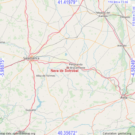
Nava de Sotrobal GPS coordinates[2]
40° 53' 25.404" North, 5° 17' 8.232" West
| Map corner | latitude | longitude |
|---|---|---|
| Upper-left | 41.41979°, | -5.98875° |
| Center: | 40.89039°, | -5.28562° |
| Lower-right: | 40.35672°, | -4.58249° |
| Map W x H: | 118.2×118.2 km | = 73.4×73.4mi |
| max Lat: | 43.74134° ⇑54.1% North |
| Nava de Sotrobal: | 40.89039° |
| min Lat: | ⇓45.9% South 27.64134° |
| min Long | Nava de Sotroba | max Long |
| -18.00367° | -5.28562° | 4.2899° |
| W 23.8%⇐ | ⇒76.2% E |
Elevation
Elevation of Nava de Sotrobal is 857 m = 2812 ft, and this is 259 m = 850 ft above average elevation for this country.
| Max E: |
1682 m = 5518 ft | 24.4% |
| Nava de Sotrobal | 857 m 2812 ft | |
| Avg. | 598 m = 1962 ft | |
Min E: |
0 m = 0 ft | 75.6% |
See also: Spain elevation on elevation.city.
Geographical zone
Nava de Sotrobal is located in North temperate zone (between Tropic of Cancer and the Arctic Circle). Distance of this Northern Tropic circle is 1940.7 km =1205.9 mi to South.| Distance of | km | miles | from Nava de Sotrobal |
|---|---|---|---|
| North Pole | 5460.5 | 3393 | to North |
| Arctic Circle | 2854.6 | 1773.8 | to North |
| Tropic Cancer | 1940.7 | 1205.9 | to South |
| Equator | 4546.6 | 2825.1 | to South |


Nearby cities:
15 places around Nava de Sotrobal: (largest is in red/bold)
• Alconada
6.9 km =4.3 mi,  289°
289°
• Aldeaseca de la Frontera
8.7 km =5.4 mi,  49°
49°
• Bóveda del Río Almar
7.3 km =4.5 mi,  120°
120°
• Cantaracillo
10.4 km =6.5 mi,  81°
81°
• Coca de Alba
6.8 km =4.2 mi,  258°
258°
• Macotera
6.6 km =4.1 mi,  179°
179°
• Mancera de Abajo
9.2 km =5.7 mi,  127°
127°
• Pedrosillo de Alba
11.9 km =7.4 mi,  230°
230°
• Peñaranda de Bracamonte
7.3 km =4.5 mi, 80°
• Peñarandilla
9.1 km =5.7 mi,  265°
265°
• Salmoral
11.4 km =7.1 mi,  150°
150°
• Santiago de la Puebla
9.9 km =6.2 mi, 177°
• Tordillos
7 km =4.3 mi, 233°
• Ventosa del Río Almar
6.7 km =4.2 mi,  307°
307°
• Villar de Gallimazo
7 km =4.3 mi,  358°
358°
Sources, notices
• [Note1] Compared only with cities in Spain existing in our database
• [Src1] Map data: © OpenStreetMap contributors (CC-BY-SA)
• [Src2] Other city data from geonames.org with taken over terms of usage.
• [Src3] Geographical zone / Annual Mean Temperature by Robert A. Rohde @ Wikipedia
