Tineo geodata
Tineo (Asturias) is a seat of a third-order administrative division; located in Spain in Europe/Madrid (GMT+2) time zone. With population of 11,146 people, there are 791 cities with bigger population in this country. Compared to other cities in Spain, 98.1% of cities are located further ↓South; 90.5% of cities are located further →East and 54.4% of cities have lower elevation than Tineo. Note1


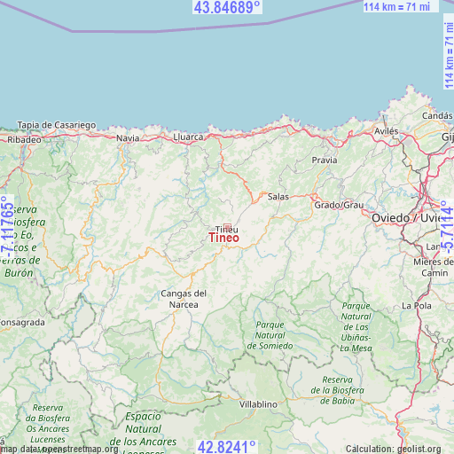
Tineo GPS coordinates[2]
43° 20' 15.54" North, 6° 24' 52.272" West
| Map corner | latitude | longitude |
|---|---|---|
| Upper-left | 43.84689°, | -7.11765° |
| Center: | 43.33765°, | -6.41452° |
| Lower-right: | 42.8241°, | -5.7114° |
| Map W x H: | 113.7×113.7 km | = 70.6×70.6mi |
| max Lat: | 43.74134° ⇑1.9% North |
| Tineo: | 43.33765° |
| min Lat: | ⇓98.1% South 27.64134° |
| min Long | Tineo | max Long |
| -18.00367° | -6.41452° | 4.2899° |
| W 9.5%⇐ | ⇒90.5% E |
Elevation
Elevation of Tineo is 704 m = 2310 ft, and this is 106 m = 348 ft above average elevation for this country.
| Max E: |
1682 m = 5518 ft | 45.6% |
| Tineo | 704 m 2310 ft | |
| Avg. | 598 m = 1962 ft | |
Min E: |
0 m = 0 ft | 54.4% |
See also: Spain elevation on elevation.city.
Geographical zone
Tineo is located in North temperate zone (between Tropic of Cancer and the Arctic Circle). Distance of this Northern Tropic circle is 2212.8 km =1375 mi to South.| Distance of | km | miles | from Tineo |
|---|---|---|---|
| North Pole | 5188.4 | 3223.9 | to North |
| Arctic Circle | 2582.5 | 1604.7 | to North |
| Tropic Cancer | 2212.8 | 1375 | to South |
| Equator | 4818.7 | 2994.2 | to South |


Nearby cities:
15 places around Tineo: (largest is in red/bold)
• Belmonte
17 km =10.6 mi,  111°
111°
• Cangas del Narcea
20.4 km =12.7 mi,  212°
212°
• Coaña
33.8 km =21 mi,  305°
305°
• Cudillero
33.1 km =20.6 mi,  40°
40°
• Grado
28.1 km =17.5 mi,  78°
78°
• La Plaza
32 km =19.9 mi,  127°
127°
• Muros de Nalón
33.9 km =21.1 mi,  47°
47°
• Navia
33 km =20.5 mi, 311°
• Pola de Allande
18.2 km =11.3 mi,  246°
246°
• Pola de Somiedo
30.1 km =18.7 mi,  154°
154°
• Pravia
29.7 km =18.5 mi,  55°
55°
• Proaza
33.6 km =20.9 mi, 106°
• Salas
14.9 km =9.3 mi, 56°
• Vilaión
26.5 km =16.5 mi,  297°
297°
• Villapedre
29.9 km =18.6 mi,  320°
320°
Sources, notices
• [Note1] Compared only with cities in Spain existing in our database
• [Src1] Map data: © OpenStreetMap contributors (CC-BY-SA)
• [Src2] Other city data from geonames.org with taken over terms of usage.
• [Src3] Geographical zone / Annual Mean Temperature by Robert A. Rohde @ Wikipedia
