Belmonte geodata
Belmonte (Asturias) is a populated place; located in Spain in Europe/Madrid (GMT+2) time zone. With population of 2,011 people, there are 2163 cities with bigger population in this country. Compared to other cities in Spain, 97.3% of cities are located further ↓South; 88.7% of cities are located further →East and 81% of cities have higher elevation than Belmonte. Note1
Administrative division(s):
- Level 1: Asturias
- Level 2: Province of Asturias
- Level 3: Belmonte de Miranda


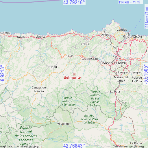
Belmonte GPS coordinates[2]
43° 16' 56.82" North, 6° 13' 5.448" West
| Map corner | latitude | longitude |
|---|---|---|
| Upper-left | 43.79216°, | -6.9213° |
| Center: | 43.28245°, | -6.21818° |
| Lower-right: | 42.76843°, | -5.51505° |
| Map W x H: | 113.8×113.8 km | = 70.7×70.7mi |
| max Lat: | 43.74134° ⇑2.7% North |
| Belmonte: | 43.28245° |
| min Lat: | ⇓97.3% South 27.64134° |
| min Long | Belmonte | max Long |
| -18.00367° | -6.21818° | 4.2899° |
| W 11.3%⇐ | ⇒88.7% E |
Elevation
Elevation of Belmonte is 203 m = 666 ft, and this is 395 m = 1296 ft below average elevation for this country.
| Max E: |
1682 m = 5518 ft | 81% |
| Avg. | 598 m = 1962 ft | |
| Belmonte | 203 m = 666 ft | |
Min E: |
0 m = 0 ft | 19% |
See also: Spain elevation on elevation.city.
Geographical zone
Belmonte is located in North temperate zone (between Tropic of Cancer and the Arctic Circle). Distance of this Northern Tropic circle is 2206.6 km =1371.1 mi to South.| Distance of | km | miles | from Belmonte |
|---|---|---|---|
| North Pole | 5194.5 | 3227.7 | to North |
| Arctic Circle | 2588.6 | 1608.5 | to North |
| Tropic Cancer | 2206.6 | 1371.1 | to South |
| Equator | 4812.6 | 2990.4 | to South |


Nearby cities:
15 places around Belmonte: (largest is in red/bold)
• Bárzana
24.2 km =15 mi,  125°
125°
• Cangas del Narcea
29.1 km =18.1 mi,  247°
247°
• Castandiello
26.4 km =16.4 mi,  90°
90°
• Grado
16.5 km =10.3 mi,  44°
44°
• Illas
30.9 km =19.2 mi, 39°
• La Plaza
16.3 km =10.1 mi,  143°
143°
• Llanera
30.6 km =19 mi,  49°
49°
• Muros de Nalón
30.4 km =18.9 mi,  17°
17°
• Pola de Somiedo
21.3 km =13.2 mi,  188°
188°
• Pravia
24.5 km =15.2 mi, 20°
• Proaza
16.7 km =10.4 mi,  101°
101°
• Salas
14.8 km =9.2 mi,  346°
346°
• San Claudio
25.5 km =15.8 mi,  72°
72°
• Soto del Barco
30.3 km =18.8 mi, 23°
• Tineo
17 km =10.6 mi,  291°
291°
Sources, notices
• [Note1] Compared only with cities in Spain existing in our database
• [Src1] Map data: © OpenStreetMap contributors (CC-BY-SA)
• [Src2] Other city data from geonames.org with taken over terms of usage.
• [Src3] Geographical zone / Annual Mean Temperature by Robert A. Rohde @ Wikipedia
