Vilada geodata
Vilada (Catalonia) is a seat of a third-order administrative division; located in Spain in Europe/Madrid (GMT+2) time zone. In our database, there are 6762 cities with bigger population. Compared to other cities in Spain, 77.6% of cities are located further ↓South; 93.2% of cities are located further ←West and 57.6% of cities have lower elevation than Vilada. Note1


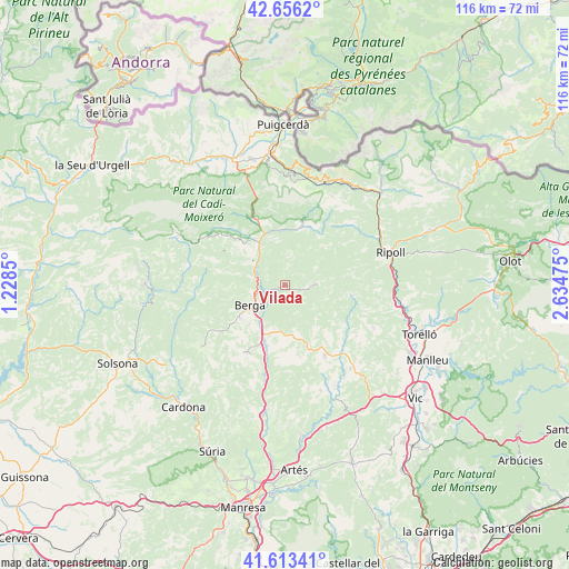
Vilada GPS coordinates[2]
42° 8' 13.02" North, 1° 55' 53.832" East
| Map corner | latitude | longitude |
|---|---|---|
| Upper-left | 42.6562°, | 1.2285° |
| Center: | 42.13695°, | 1.93162° |
| Lower-right: | 41.61341°, | 2.63475° |
| Map W x H: | 115.9×115.9 km | = 72×72mi |
| max Lat: | 43.74134° ⇑22.4% North |
| Vilada: | 42.13695° |
| min Lat: | ⇓77.6% South 27.64134° |
| min Long | Vilada | max Long |
| -18.00367° | 1.93162° | 4.2899° |
| W 93.2%⇐ | ⇒6.8% E |
Elevation
Elevation of Vilada is 727 m = 2385 ft, and this is 129 m = 423 ft above average elevation for this country.
| Max E: |
1682 m = 5518 ft | 42.4% |
| Vilada | 727 m 2385 ft | |
| Avg. | 598 m = 1962 ft | |
Min E: |
0 m = 0 ft | 57.6% |
See also: Spain elevation on elevation.city.
Geographical zone
Vilada is located in North temperate zone (between Tropic of Cancer and the Arctic Circle). Distance of this Northern Tropic circle is 2079.3 km =1292 mi to South.| Distance of | km | miles | from Vilada |
|---|---|---|---|
| North Pole | 5321.9 | 3306.9 | to North |
| Arctic Circle | 2716 | 1687.6 | to North |
| Tropic Cancer | 2079.3 | 1292 | to South |
| Equator | 4685.2 | 2911.2 | to South |


Nearby cities:
15 places around Vilada: (largest is in red/bold)
• Alpens
14.1 km =8.8 mi,  97°
97°
• Avià
10.3 km =6.4 mi,  220°
220°
• Bagà
14.1 km =8.8 mi,  335°
335°
• Berga
7.9 km =4.9 mi,  242°
242°
• Borredà
5.2 km =3.2 mi,  91°
91°
• Castellar del Riu
13.1 km =8.1 mi,  263°
263°
• Gironella
12.2 km =7.6 mi,  200°
200°
• Guardiola de Berguedà
11.8 km =7.3 mi, 337°
• Olvan
8.2 km =5.1 mi, 198°
• Prats de Lluçanès
15.8 km =9.8 mi,  147°
147°
• Sagàs
10.1 km =6.3 mi,  163°
163°
• Sant Julià de Cerdanyola
10.1 km =6.3 mi, 341°
• Sant Maurici de la Quar
6.6 km =4.1 mi, 154°
• Vallcebre
11.9 km =7.4 mi,  308°
308°
• les Llosses
15.3 km =9.5 mi,  84°
84°
Sources, notices
• [Note1] Compared only with cities in Spain existing in our database
• [Src1] Map data: © OpenStreetMap contributors (CC-BY-SA)
• [Src2] Other city data from geonames.org with taken over terms of usage.
• [Src3] Geographical zone / Annual Mean Temperature by Robert A. Rohde @ Wikipedia
