San Vicente de la Sonsierra geodata
San Vicente de la Sonsierra (La Rioja) is a seat of a third-order administrative division; located in Spain in Europe/Madrid (GMT+2) time zone. With population of 1,212 people, there are 2715 cities with bigger population in this country. Compared to other cities in Spain, 88.6% of cities are located further ↓South; 57.9% of cities are located further ←West and 62.8% of cities have higher elevation than San Vicente de la Sonsierra. Note1
Administrative division(s):
- Level 1: La Rioja
- Level 2: Provincia de La Rioja
- Level 3: San Vicente de la Sonsierra
Current local time in San Vicente de la Sonsierra:
12:01 AM, FridayDifference from your time zone: hours


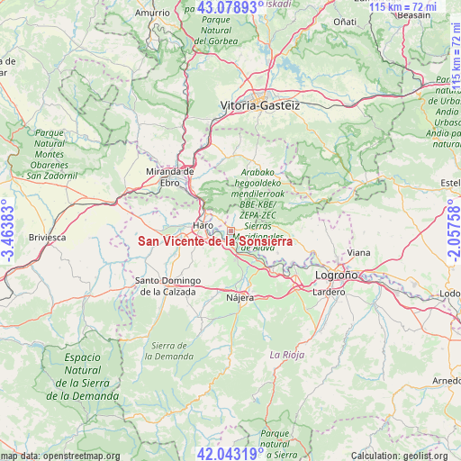
San Vicente de la Sonsierra GPS coordinates[2]
42° 33' 47.556" North, 2° 45' 38.556" West
| Map corner | latitude | longitude |
|---|---|---|
| Upper-left | 43.07893°, | -3.46383° |
| Center: | 42.56321°, | -2.76071° |
| Lower-right: | 42.04319°, | -2.05758° |
| Map W x H: | 115.2×115.2 km | = 71.6×71.6mi |
| max Lat: | 43.74134° ⇑11.4% North |
| San Vicente de la Sonsierra: | 42.56321° |
| min Lat: | ⇓88.6% South 27.64134° |
| min Long | San Vicente de | max Long |
| -18.00367° | -2.76071° | 4.2899° |
| W 57.9%⇐ | ⇒42.1% E |
Elevation
Elevation of San Vicente de la Sonsierra is 489 m = 1604 ft, and this is 109 m = 358 ft below average elevation for this country.
| Max E: |
1682 m = 5518 ft | 62.8% |
| Avg. | 598 m = 1962 ft | |
| San Vicente de la Sonsierra | 489 m = 1604 ft | |
Min E: |
0 m = 0 ft | 37.2% |
See also: Spain elevation on elevation.city.
Geographical zone
San Vicente de la Sonsierra is located in North temperate zone (between Tropic of Cancer and the Arctic Circle). Distance of this Northern Tropic circle is 2126.7 km =1321.5 mi to South.| Distance of | km | miles | from San Vicente de la Sonsierra |
|---|---|---|---|
| North Pole | 5274.5 | 3277.4 | to North |
| Arctic Circle | 2668.6 | 1658.2 | to North |
| Tropic Cancer | 2126.7 | 1321.5 | to South |
| Equator | 4732.6 | 2940.7 | to South |


Nearby cities:
15 places around San Vicente de la Sonsierra: (largest is in red/bold)
• Bastida / Labastida
4.1 km =2.5 mi,  315°
315°
• Briones
3 km =1.9 mi,  223°
223°
• Briñas
7.2 km =4.5 mi,  305°
305°
• Eskuernaga / Villabuena de Álava
8 km =5 mi,  102°
102°
• Gimileo
5.3 km =3.3 mi,  253°
253°
• Haro
7.3 km =4.5 mi,  281°
281°
• Leza
10.4 km =6.5 mi,  88°
88°
• Navaridas
11.2 km =7 mi, 100°
• Ollauri
6.5 km =4 mi, 249°
• Rodezno
8.1 km =5 mi,  239°
239°
• Samaniego
6.7 km =4.2 mi,  84°
84°
• San Asensio
7.4 km =4.6 mi,  173°
173°
• Torremontalbo
9.5 km =5.9 mi,  137°
137°
• Zarratón
11.1 km =6.9 mi, 242°
• Ábalos
4.3 km =2.7 mi, 77°
Sources, notices
• [Note1] Compared only with cities in Spain existing in our database
• [Src1] Map data: © OpenStreetMap contributors (CC-BY-SA)
• [Src2] Other city data from geonames.org with taken over terms of usage.
• [Src3] Geographical zone / Annual Mean Temperature by Robert A. Rohde @ Wikipedia
