Bastida / Labastida geodata
Bastida / Labastida (Basque Country) is a seat of a third-order administrative division; located in Spain in Europe/Madrid (GMT+2) time zone. With population of 1,363 people, there are 2584 cities with bigger population in this country. Compared to other cities in Spain, 89.3% of cities are located further ↓South; 57.5% of cities are located further ←West and 59.6% of cities have higher elevation than Bastida / Labastida. Note1
Administrative division(s):
- Level 1: Basque Country
- Level 2: Araba / Álava
- Level 3: Bastida / Labastida


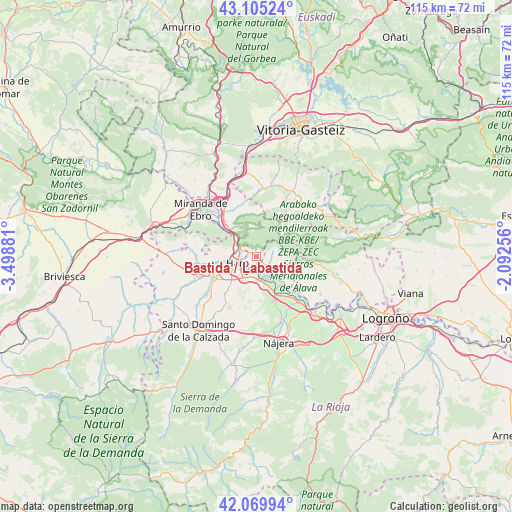
Bastida / Labastida GPS coordinates[2]
42° 35' 23.064" North, 2° 47' 44.448" West
| Map corner | latitude | longitude |
|---|---|---|
| Upper-left | 43.10524°, | -3.49881° |
| Center: | 42.58974°, | -2.79568° |
| Lower-right: | 42.06994°, | -2.09256° |
| Map W x H: | 115.1×115.1 km | = 71.5×71.5mi |
| max Lat: | 43.74134° ⇑10.7% North |
| Bastida / Labastida: | 42.58974° |
| min Lat: | ⇓89.3% South 27.64134° |
| min Long | Bastida / Labas | max Long |
| -18.00367° | -2.79568° | 4.2899° |
| W 57.5%⇐ | ⇒42.5% E |
Elevation
Elevation of Bastida / Labastida is 532 m = 1745 ft, and this is 66 m = 217 ft below average elevation for this country.
| Max E: |
1682 m = 5518 ft | 59.6% |
| Avg. | 598 m = 1962 ft | |
| Bastida / Labastida | 532 m = 1745 ft | |
Min E: |
0 m = 0 ft | 40.4% |
See also: Spain elevation on elevation.city.
Geographical zone
Bastida / Labastida is located in North temperate zone (between Tropic of Cancer and the Arctic Circle). Distance of this Northern Tropic circle is 2129.6 km =1323.3 mi to South.| Distance of | km | miles | from Bastida / Labastida |
|---|---|---|---|
| North Pole | 5271.5 | 3275.6 | to North |
| Arctic Circle | 2665.6 | 1656.3 | to North |
| Tropic Cancer | 2129.6 | 1323.3 | to South |
| Equator | 4735.5 | 2942.5 | to South |


Nearby cities:
15 places around Bastida / Labastida: (largest is in red/bold)
• Anguciana
8.8 km =5.5 mi,  258°
258°
• Briones
5.2 km =3.2 mi,  170°
170°
• Briñas
3.2 km =2 mi,  292°
292°
• Casalarreina
10.4 km =6.5 mi,  244°
244°
• Cihuri
10.8 km =6.7 mi, 255°
• Gimileo
4.9 km =3 mi,  206°
206°
• Haro
4.5 km =2.8 mi,  250°
250°
• Ollauri
6.1 km =3.8 mi, 211°
• Rodezno
8.2 km =5.1 mi, 210°
• Samaniego
9.8 km =6.1 mi,  103°
103°
• San Vicente de la Sonsierra
4.1 km =2.5 mi,  135°
135°
• Villalba de Rioja
7.8 km =4.8 mi, 286°
• Zambrana
10.5 km =6.5 mi,  319°
319°
• Zarratón
10.7 km =6.6 mi,  220°
220°
• Ábalos
7.3 km =4.5 mi,  106°
106°
Sources, notices
• [Note1] Compared only with cities in Spain existing in our database
• [Src1] Map data: © OpenStreetMap contributors (CC-BY-SA)
• [Src2] Other city data from geonames.org with taken over terms of usage.
• [Src3] Geographical zone / Annual Mean Temperature by Robert A. Rohde @ Wikipedia
