Matarrubia geodata
Matarrubia (Castille-La Mancha) is a seat of a third-order administrative division; located in Spain in Europe/Madrid (GMT+2) time zone. With population of 57 people, there are 6380 cities with bigger population in this country. Compared to other cities in Spain, 54.7% of cities are located further ↑North; 50.6% of cities are located further ←West and 77.8% of cities have lower elevation than Matarrubia. Note1
Administrative division(s):
- Level 1: Castille-La Mancha
- Level 2: Provincia de Guadalajara
- Level 3: Matarrubia


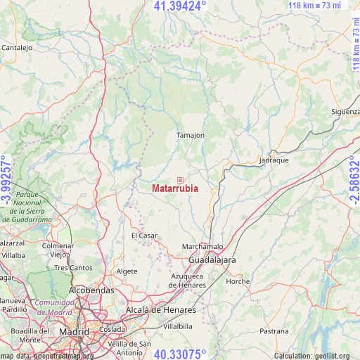
Matarrubia GPS coordinates[2]
40° 51' 52.668" North, 3° 17' 21.984" West
| Map corner | latitude | longitude |
|---|---|---|
| Upper-left | 41.39424°, | -3.99257° |
| Center: | 40.86463°, | -3.28944° |
| Lower-right: | 40.33075°, | -2.58632° |
| Map W x H: | 118.2×118.2 km | = 73.4×73.4mi |
| max Lat: | 43.74134° ⇑54.7% North |
| Matarrubia: | 40.86463° |
| min Lat: | ⇓45.3% South 27.64134° |
| min Long | Matarrubia | max Long |
| -18.00367° | -3.28944° | 4.2899° |
| W 50.6%⇐ | ⇒49.4% E |
Elevation
Elevation of Matarrubia is 877 m = 2877 ft, and this is 279 m = 915 ft above average elevation for this country.
| Max E: |
1682 m = 5518 ft | 22.2% |
| Matarrubia | 877 m 2877 ft | |
| Avg. | 598 m = 1962 ft | |
Min E: |
0 m = 0 ft | 77.8% |
See also: Spain elevation on elevation.city.
Geographical zone
Matarrubia is located in North temperate zone (between Tropic of Cancer and the Arctic Circle). Distance of this Northern Tropic circle is 1937.8 km =1204.1 mi to South.| Distance of | km | miles | from Matarrubia |
|---|---|---|---|
| North Pole | 5463.3 | 3394.7 | to North |
| Arctic Circle | 2857.5 | 1775.6 | to North |
| Tropic Cancer | 1937.8 | 1204.1 | to South |
| Equator | 4543.7 | 2823.3 | to South |


Nearby cities:
15 places around Matarrubia: (largest is in red/bold)
• Casa de Uceda
7.1 km =4.4 mi,  248°
248°
• Fuentelahiguera de Albatages
9.2 km =5.7 mi,  188°
188°
• Humanes
12.3 km =7.6 mi,  110°
110°
• Malaguilla
5.8 km =3.6 mi,  149°
149°
• Mohernando
12.1 km =7.5 mi,  125°
125°
• Málaga del Fresno
9.4 km =5.8 mi,  156°
156°
• Puebla de Beleña
6.7 km =4.2 mi,  67°
67°
• Retiendas
11.6 km =7.2 mi,  7°
7°
• Robledillo de Mohernando
5.1 km =3.2 mi, 107°
• Tortuero
9.3 km =5.8 mi,  326°
326°
• Uceda
14.6 km =9.1 mi,  258°
258°
• Valdepeñas de la Sierra
9.2 km =5.7 mi,  299°
299°
• Valdesotos
10.5 km =6.5 mi,  343°
343°
• Villaseca de Uceda
7.2 km =4.5 mi,  224°
224°
• Viñuelas
9.1 km =5.7 mi,  208°
208°
Sources, notices
• [Note1] Compared only with cities in Spain existing in our database
• [Src1] Map data: © OpenStreetMap contributors (CC-BY-SA)
• [Src2] Other city data from geonames.org with taken over terms of usage.
• [Src3] Geographical zone / Annual Mean Temperature by Robert A. Rohde @ Wikipedia
