Ríofrío de Aliste geodata
Ríofrío de Aliste (Castille and León) is a populated place; located in Spain in Europe/Madrid (GMT+2) time zone. With population of 1,008 people, there are 2931 cities with bigger population in this country. Compared to other cities in Spain, 69% of cities are located further ↓South; 88.2% of cities are located further →East and 67.5% of cities have lower elevation than Ríofrío de Aliste. Note1
Administrative division(s):
- Level 1: Castille and León
- Level 2: Provincia de Zamora
- Level 3: Riofrío de Aliste


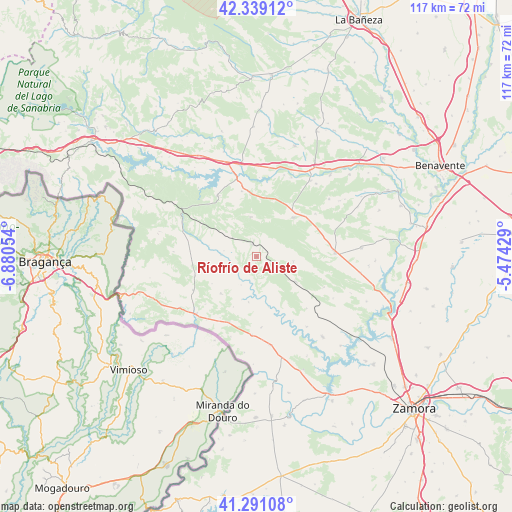
Ríofrío de Aliste GPS coordinates[2]
41° 49' 2.064" North, 6° 10' 38.676" West
| Map corner | latitude | longitude |
|---|---|---|
| Upper-left | 42.33912°, | -6.88054° |
| Center: | 41.81724°, | -6.17741° |
| Lower-right: | 41.29108°, | -5.47429° |
| Map W x H: | 116.5×116.5 km | = 72.4×72.4mi |
| max Lat: | 43.74134° ⇑31% North |
| Ríofrío de Aliste: | 41.81724° |
| min Lat: | ⇓69% South 27.64134° |
| min Long | Ríofrío de Al | max Long |
| -18.00367° | -6.17741° | 4.2899° |
| W 11.8%⇐ | ⇒88.2% E |
Elevation
Elevation of Ríofrío de Aliste is 795 m = 2608 ft, and this is 197 m = 646 ft above average elevation for this country.
| Max E: |
1682 m = 5518 ft | 32.5% |
| Ríofrío de Aliste | 795 m 2608 ft | |
| Avg. | 598 m = 1962 ft | |
Min E: |
0 m = 0 ft | 67.5% |
See also: Spain elevation on elevation.city.
Geographical zone
Ríofrío de Aliste is located in North temperate zone (between Tropic of Cancer and the Arctic Circle). Distance of this Northern Tropic circle is 2043.7 km =1269.9 mi to South.| Distance of | km | miles | from Ríofrío de Aliste |
|---|---|---|---|
| North Pole | 5357.4 | 3328.9 | to North |
| Arctic Circle | 2751.5 | 1709.7 | to North |
| Tropic Cancer | 2043.7 | 1269.9 | to South |
| Equator | 4649.6 | 2889.1 | to South |


Nearby cities:
15 places around Ríofrío de Aliste: (largest is in red/bold)
• Ferreras de Abajo
12 km =7.5 mi,  42°
42°
• Ferreras de Arriba
9.2 km =5.7 mi,  351°
351°
• Ferreruela
10.4 km =6.5 mi,  122°
122°
• Gallegos del Río
9.2 km =5.7 mi,  178°
178°
• Losacino
17.2 km =10.7 mi,  151°
151°
• Losacio
16.4 km =10.2 mi,  136°
136°
• Mahide
17.6 km =10.9 mi,  289°
289°
• Otero de Bodas
13.7 km =8.5 mi,  9°
9°
• Rabanales
11.7 km =7.3 mi,  224°
224°
• Samir de los Caños
16.1 km =10 mi, 176°
• San Vicente de la Cabeza
6.1 km =3.8 mi,  259°
259°
• San Vitero
14.9 km =9.3 mi,  252°
252°
• Tábara
17.7 km =11 mi,  87°
87°
• Vegalatrave
14.3 km =8.9 mi,  155°
155°
• Villardeciervos
16.6 km =10.3 mi,  326°
326°
Sources, notices
• [Note1] Compared only with cities in Spain existing in our database
• [Src1] Map data: © OpenStreetMap contributors (CC-BY-SA)
• [Src2] Other city data from geonames.org with taken over terms of usage.
• [Src3] Geographical zone / Annual Mean Temperature by Robert A. Rohde @ Wikipedia
