Abadín geodata
Abadín (Galicia) is a seat of a third-order administrative division; located in Spain in Europe/Madrid (GMT+2) time zone. With population of 3,193 people, there are 1663 cities with bigger population in this country. Compared to other cities in Spain, 98.5% of cities are located further ↓South; 95.4% of cities are located further →East and 63.9% of cities have higher elevation than Abadín. Note1


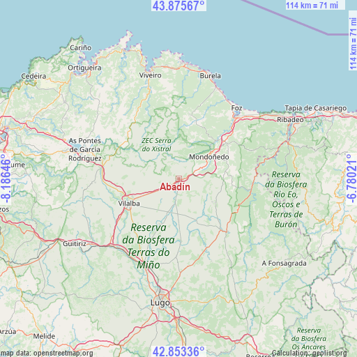
Abadín GPS coordinates[2]
43° 22' 0.012" North, 7° 28' 59.988" West
| Map corner | latitude | longitude |
|---|---|---|
| Upper-left | 43.87567°, | -8.18646° |
| Center: | 43.36667°, | -7.48333° |
| Lower-right: | 42.85336°, | -6.78021° |
| Map W x H: | 113.7×113.7 km | = 70.6×70.6mi |
| max Lat: | 43.74134° ⇑1.5% North |
| Abadín: | 43.36667° |
| min Lat: | ⇓98.5% South 27.64134° |
| min Long | Abadín | max Long |
| -18.00367° | -7.48333° | 4.2899° |
| W 4.6%⇐ | ⇒95.4% E |
Elevation
Elevation of Abadín is 474 m = 1555 ft, and this is 124 m = 407 ft below average elevation for this country.
| Max E: |
1682 m = 5518 ft | 63.9% |
| Avg. | 598 m = 1962 ft | |
| Abadín | 474 m = 1555 ft | |
Min E: |
0 m = 0 ft | 36.1% |
See also: Spain elevation on elevation.city.
Geographical zone
Abadín is located in North temperate zone (between Tropic of Cancer and the Arctic Circle). Distance of this Northern Tropic circle is 2216 km =1377 mi to South.| Distance of | km | miles | from Abadín |
|---|---|---|---|
| North Pole | 5185.1 | 3221.9 | to North |
| Arctic Circle | 2579.3 | 1602.7 | to North |
| Tropic Cancer | 2216 | 1377 | to South |
| Equator | 4821.9 | 2996.2 | to South |


Nearby cities:
15 places around Abadín: (largest is in red/bold)
• Barreiros
27.4 km =17 mi,  47°
47°
• Castro de Rei
18.8 km =11.7 mi,  159°
159°
• Foz
29.1 km =18.1 mi,  39°
39°
• Meira
22.9 km =14.2 mi,  138°
138°
• Mondoñedo
7.7 km =4.8 mi,  61°
61°
• Mondoñedo
12.1 km =7.5 mi, 56°
• Mos
24 km =14.9 mi,  193°
193°
• Muras
22.4 km =13.9 mi,  299°
299°
• Outeiro
29.1 km =18.1 mi,  147°
147°
• Pol
27.2 km =16.9 mi, 152°
• Puente Nuevo
23.4 km =14.5 mi,  94°
94°
• Ríotorto
20.3 km =12.6 mi,  95°
95°
• San Tirso de Abres
27.9 km =17.3 mi,  80°
80°
• Trabada
24.8 km =15.4 mi,  69°
69°
• Vilalba
17.7 km =11 mi,  244°
244°
Sources, notices
• [Note1] Compared only with cities in Spain existing in our database
• [Src1] Map data: © OpenStreetMap contributors (CC-BY-SA)
• [Src2] Other city data from geonames.org with taken over terms of usage.
• [Src3] Geographical zone / Annual Mean Temperature by Robert A. Rohde @ Wikipedia
