Pradales geodata
Pradales (Castille and León) is a seat of a third-order administrative division; located in Spain in Europe/Madrid (GMT+2) time zone. With population of 59 people, there are 6361 cities with bigger population in this country. Compared to other cities in Spain, 59.7% of cities are located further ↓South; 55.5% of cities are located further →East and 96.6% of cities have lower elevation than Pradales. Note1
Administrative division(s):
- Level 1: Castille and León
- Level 2: Provincia de Segovia
- Level 3: Pradales


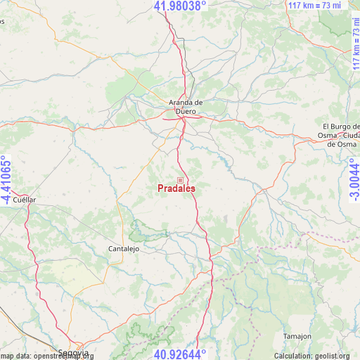
Pradales GPS coordinates[2]
41° 27' 19.98" North, 3° 42' 27.108" West
| Map corner | latitude | longitude |
|---|---|---|
| Upper-left | 41.98038°, | -4.41065° |
| Center: | 41.45555°, | -3.70753° |
| Lower-right: | 40.92644°, | -3.0044° |
| Map W x H: | 117.2×117.2 km | = 72.8×72.8mi |
| max Lat: | 43.74134° ⇑40.3% North |
| Pradales: | 41.45555° |
| min Lat: | ⇓59.7% South 27.64134° |
| min Long | Pradales | max Long |
| -18.00367° | -3.70753° | 4.2899° |
| W 44.5%⇐ | ⇒55.5% E |
Elevation
Elevation of Pradales is 1191 m = 3907 ft, and this is 593 m = 1946 ft above average elevation for this country.
| Max E: |
1682 m = 5518 ft | 3.4% |
| Pradales | 1191 m 3907 ft | |
| Avg. | 598 m = 1962 ft | |
Min E: |
0 m = 0 ft | 96.6% |
See also: Spain elevation on elevation.city.
Geographical zone
Pradales is located in North temperate zone (between Tropic of Cancer and the Arctic Circle). Distance of this Northern Tropic circle is 2003.5 km =1244.9 mi to South.| Distance of | km | miles | from Pradales |
|---|---|---|---|
| North Pole | 5397.6 | 3353.9 | to North |
| Arctic Circle | 2791.7 | 1734.7 | to North |
| Tropic Cancer | 2003.5 | 1244.9 | to South |
| Equator | 4609.4 | 2864.1 | to South |


Nearby cities:
15 places around Pradales: (largest is in red/bold)
• Aldeonte
11.9 km =7.4 mi,  168°
168°
• Castroserracín
10.5 km =6.5 mi,  228°
228°
• Cedillo de la Torre
9.1 km =5.7 mi,  111°
111°
• Encinas
9.5 km =5.9 mi,  159°
159°
• Fresno de la Fuente
8.7 km =5.4 mi,  143°
143°
• Fuentenebro
9 km =5.6 mi,  334°
334°
• Honrubia de la Cuesta
6.1 km =3.8 mi,  2°
2°
• Montejo de la Vega de la Serrezuela
11.4 km =7.1 mi,  22°
22°
• Navares de Ayuso
9 km =5.6 mi,  179°
179°
• Navares de Enmedio
8.4 km =5.2 mi,  188°
188°
• Navares de las Cuevas
5.8 km =3.6 mi,  218°
218°
• Pardilla
10.7 km =6.6 mi,  358°
358°
• Torreadrada
11.1 km =6.9 mi,  263°
263°
• Valdevacas de Montejo
9.4 km =5.8 mi,  39°
39°
• Villaverde de Montejo
8.6 km =5.3 mi,  30°
30°
Sources, notices
• [Note1] Compared only with cities in Spain existing in our database
• [Src1] Map data: © OpenStreetMap contributors (CC-BY-SA)
• [Src2] Other city data from geonames.org with taken over terms of usage.
• [Src3] Geographical zone / Annual Mean Temperature by Robert A. Rohde @ Wikipedia
