Fuentenebro geodata
Fuentenebro (Castille and León) is a seat of a third-order administrative division; located in Spain in Europe/Madrid (GMT+2) time zone. With population of 165 people, there are 5307 cities with bigger population in this country. Compared to other cities in Spain, 61.5% of cities are located further ↓South; 56.1% of cities are located further →East and 82.5% of cities have lower elevation than Fuentenebro. Note1
Administrative division(s):
- Level 1: Castille and León
- Level 2: Provincia de Burgos
- Level 3: Fuentenebro


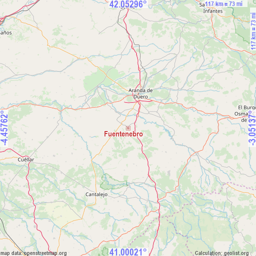
Fuentenebro GPS coordinates[2]
41° 31' 43.428" North, 3° 45' 16.164" West
| Map corner | latitude | longitude |
|---|---|---|
| Upper-left | 42.05296°, | -4.45762° |
| Center: | 41.52873°, | -3.75449° |
| Lower-right: | 41.00021°, | -3.05137° |
| Map W x H: | 117.1×117.1 km | = 72.8×72.8mi |
| max Lat: | 43.74134° ⇑38.5% North |
| Fuentenebro: | 41.52873° |
| min Lat: | ⇓61.5% South 27.64134° |
| min Long | Fuentenebro | max Long |
| -18.00367° | -3.75449° | 4.2899° |
| W 43.9%⇐ | ⇒56.1% E |
Elevation
Elevation of Fuentenebro is 922 m = 3025 ft, and this is 324 m = 1063 ft above average elevation for this country.
| Max E: |
1682 m = 5518 ft | 17.5% |
| Fuentenebro | 922 m 3025 ft | |
| Avg. | 598 m = 1962 ft | |
Min E: |
0 m = 0 ft | 82.5% |
See also: Spain elevation on elevation.city.
Geographical zone
Fuentenebro is located in North temperate zone (between Tropic of Cancer and the Arctic Circle). Distance of this Northern Tropic circle is 2011.6 km =1249.9 mi to South.| Distance of | km | miles | from Fuentenebro |
|---|---|---|---|
| North Pole | 5389.5 | 3348.9 | to North |
| Arctic Circle | 2783.6 | 1729.6 | to North |
| Tropic Cancer | 2011.6 | 1249.9 | to South |
| Equator | 4617.6 | 2869.2 | to South |


Nearby cities:
15 places around Fuentenebro: (largest is in red/bold)
• Adrada de Haza
9.3 km =5.8 mi,  321°
321°
• Campillo de Aranda
9.3 km =5.8 mi,  12°
12°
• Fuentemolinos
11.6 km =7.2 mi, 316°
• Haza
11.1 km =6.9 mi,  332°
332°
• Honrubia de la Cuesta
4.7 km =2.9 mi,  116°
116°
• Hontangas
6.9 km =4.3 mi, 330°
• Milagros
6.9 km =4.3 mi,  41°
41°
• Montejo de la Vega de la Serrezuela
8.7 km =5.4 mi,  73°
73°
• Moradillo de Roa
4 km =2.5 mi,  309°
309°
• Pardilla
4.4 km =2.7 mi,  54°
54°
• Pradales
9 km =5.6 mi,  154°
154°
• Torreadrada
11.7 km =7.3 mi,  217°
217°
• Torregalindo
6 km =3.7 mi,  1°
1°
• Valdevacas de Montejo
9.9 km =6.2 mi,  95°
95°
• Villaverde de Montejo
8.4 km =5.2 mi,  94°
94°
Sources, notices
• [Note1] Compared only with cities in Spain existing in our database
• [Src1] Map data: © OpenStreetMap contributors (CC-BY-SA)
• [Src2] Other city data from geonames.org with taken over terms of usage.
• [Src3] Geographical zone / Annual Mean Temperature by Robert A. Rohde @ Wikipedia
