Pozán de Vero geodata
Pozán de Vero (Aragon) is a seat of a third-order administrative division; located in Spain in Europe/Madrid (GMT+2) time zone. With population of 241 people, there are 4804 cities with bigger population in this country. Compared to other cities in Spain, 76% of cities are located further ↓South; 87.2% of cities are located further ←West and 68.3% of cities have higher elevation than Pozán de Vero. Note1


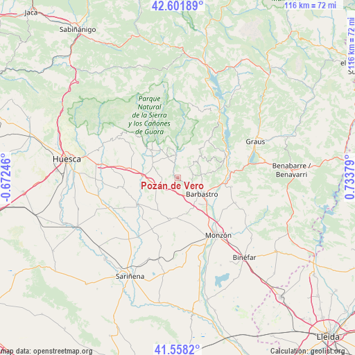
Pozán de Vero GPS coordinates[2]
42° 4' 55.884" North, 0° 1' 50.376" East
| Map corner | latitude | longitude |
|---|---|---|
| Upper-left | 42.60189°, | -0.67246° |
| Center: | 42.08219°, | 0.03066° |
| Lower-right: | 41.5582°, | 0.73379° |
| Map W x H: | 116×116 km | = 72.1×72.1mi |
| max Lat: | 43.74134° ⇑24% North |
| Pozán de Vero: | 42.08219° |
| min Lat: | ⇓76% South 27.64134° |
| min Long | Pozán de Vero | max Long |
| -18.00367° | 0.03066° | 4.2899° |
| W 87.2%⇐ | ⇒12.8% E |
Elevation
Elevation of Pozán de Vero is 412 m = 1352 ft, and this is 186 m = 610 ft below average elevation for this country.
| Max E: |
1682 m = 5518 ft | 68.3% |
| Avg. | 598 m = 1962 ft | |
| Pozán de Vero | 412 m = 1352 ft | |
Min E: |
0 m = 0 ft | 31.7% |
See also: Spain elevation on elevation.city.
Geographical zone
Pozán de Vero is located in North temperate zone (between Tropic of Cancer and the Arctic Circle). Distance of this Northern Tropic circle is 2073.2 km =1288.2 mi to South.| Distance of | km | miles | from Pozán de Vero |
|---|---|---|---|
| North Pole | 5328 | 3310.7 | to North |
| Arctic Circle | 2722.1 | 1691.4 | to North |
| Tropic Cancer | 2073.2 | 1288.2 | to South |
| Equator | 4679.1 | 2907.5 | to South |


Nearby cities:
15 places around Pozán de Vero: (largest is in red/bold)
• Abiego
9.3 km =5.8 mi,  297°
297°
• Adahuesca
7.8 km =4.8 mi,  335°
335°
• Alquézar
10.1 km =6.3 mi,  357°
357°
• Azara
5.1 km =3.2 mi,  255°
255°
• Azlor
6.5 km =4 mi,  281°
281°
• Barbastro
9.5 km =5.9 mi,  123°
123°
• Barbuñales
11.5 km =7.1 mi,  236°
236°
• Bierge
12.9 km =8 mi,  313°
313°
• Castillazuelo
3.3 km =2.1 mi, 119°
• Colungo
10.4 km =6.5 mi,  17°
17°
• Laluenga
10.5 km =6.5 mi,  217°
217°
• Laperdiguera
12 km =7.5 mi,  212°
212°
• Peraltilla
5.1 km =3.2 mi,  232°
232°
• Salas Altas
4.7 km =2.9 mi,  41°
41°
• Salas Bajas
4.8 km =3 mi,  65°
65°
Sources, notices
• [Note1] Compared only with cities in Spain existing in our database
• [Src1] Map data: © OpenStreetMap contributors (CC-BY-SA)
• [Src2] Other city data from geonames.org with taken over terms of usage.
• [Src3] Geographical zone / Annual Mean Temperature by Robert A. Rohde @ Wikipedia
