Abiego geodata
Abiego (Aragon) is a seat of a third-order administrative division; located in Spain in Europe/Madrid (GMT+2) time zone. With population of 290 people, there are 4545 cities with bigger population in this country. Compared to other cities in Spain, 77.1% of cities are located further ↓South; 86.6% of cities are located further ←West and 59.1% of cities have higher elevation than Abiego. Note1


Abiego GPS coordinates[2]
42° 7' 15.384" North, 0° 4' 7.428" West
| Map corner | latitude | longitude |
|---|---|---|
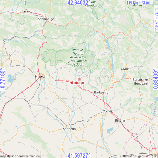
| Upper-left | 42.64032°, | -0.77185° |
| Center: | 42.12094°, | -0.06873° |
| Lower-right: | 41.59727°, | 0.63439° |
| Map W x H: | 116×116 km | = 72.1×72.1mi |
| max Lat: | 43.74134° ⇑22.9% North |
| Abiego: | 42.12094° |
| min Lat: | ⇓77.1% South 27.64134° |
| min Long | Abiego | max Long |
| -18.00367° | -0.06873° | 4.2899° |
| W 86.6%⇐ | ⇒13.4% E |
Elevation
Elevation of Abiego is 539 m = 1768 ft, and this is 59 m = 194 ft below average elevation for this country.
| Max E: |
1682 m = 5518 ft | 59.1% |
| Avg. | 598 m = 1962 ft | |
| Abiego | 539 m = 1768 ft | |
Min E: |
0 m = 0 ft | 40.9% |
See also: Spain elevation on elevation.city.
Geographical zone
Abiego is located in North temperate zone (between Tropic of Cancer and the Arctic Circle). Distance of this Northern Tropic circle is 2077.5 km =1290.9 mi to South.| Distance of | km | miles | from Abiego |
|---|---|---|---|
| North Pole | 5323.7 | 3308 | to North |
| Arctic Circle | 2717.8 | 1688.8 | to North |
| Tropic Cancer | 2077.5 | 1290.9 | to South |
| Equator | 4683.4 | 2910.1 | to South |


Nearby cities:
15 places around Abiego: (largest is in red/bold)
• Adahuesca
5.7 km =3.5 mi,  60°
60°
• Alquézar
9.7 km =6 mi,  53°
53°
• Angüés
7 km =4.3 mi,  261°
261°
• Antillón
12.2 km =7.6 mi,  219°
219°
• Azara
6.5 km =4 mi,  149°
149°
• Azlor
3.5 km =2.2 mi, 147°
• Barbuñales
10.7 km =6.6 mi,  187°
187°
• Bierge
4.7 km =2.9 mi,  345°
345°
• Casbas de Huesca
7 km =4.3 mi,  303°
303°
• Castillazuelo
12.5 km =7.8 mi,  118°
118°
• Colungo
12.6 km =7.8 mi, 63°
• Ibieca
12.3 km =7.6 mi,  291°
291°
• Peraltilla
8.5 km =5.3 mi, 150°
• Pozán de Vero
9.3 km =5.8 mi, 117°
• Salas Altas
11.3 km =7 mi,  93°
93°
Sources, notices
• [Note1] Compared only with cities in Spain existing in our database
• [Src1] Map data: © OpenStreetMap contributors (CC-BY-SA)
• [Src2] Other city data from geonames.org with taken over terms of usage.
• [Src3] Geographical zone / Annual Mean Temperature by Robert A. Rohde @ Wikipedia
