Alquézar geodata
Alquézar (Aragon) is a seat of a third-order administrative division; located in Spain in Europe/Madrid (GMT+2) time zone. With population of 307 people, there are 4476 cities with bigger population in this country. Compared to other cities in Spain, 78.6% of cities are located further ↓South; 87.1% of cities are located further ←West and 52% of cities have higher elevation than Alquézar. Note1


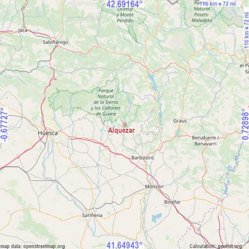
Alquézar GPS coordinates[2]
42° 10' 21.648" North, 0° 1' 33.096" East
| Map corner | latitude | longitude |
|---|---|---|
| Upper-left | 42.69164°, | -0.67727° |
| Center: | 42.17268°, | 0.02586° |
| Lower-right: | 41.64943°, | 0.72898° |
| Map W x H: | 115.9×115.9 km | = 72×72mi |
| max Lat: | 43.74134° ⇑21.4% North |
| Alquézar: | 42.17268° |
| min Lat: | ⇓78.6% South 27.64134° |
| min Long | Alquézar | max Long |
| -18.00367° | 0.02586° | 4.2899° |
| W 87.1%⇐ | ⇒12.9% E |
Elevation
Elevation of Alquézar is 637 m = 2090 ft, and this is 39 m = 128 ft above average elevation for this country.
| Max E: |
1682 m = 5518 ft | 52% |
| Alquézar | 637 m 2090 ft | |
| Avg. | 598 m = 1962 ft | |
Min E: |
0 m = 0 ft | 48% |
See also: Spain elevation on elevation.city.
Geographical zone
Alquézar is located in North temperate zone (between Tropic of Cancer and the Arctic Circle). Distance of this Northern Tropic circle is 2083.2 km =1294.4 mi to South.| Distance of | km | miles | from Alquézar |
|---|---|---|---|
| North Pole | 5317.9 | 3304.4 | to North |
| Arctic Circle | 2712 | 1685.2 | to North |
| Tropic Cancer | 2083.2 | 1294.4 | to South |
| Equator | 4689.2 | 2913.7 | to South |


Nearby cities:
15 places around Alquézar: (largest is in red/bold)
• Abiego
9.7 km =6 mi,  233°
233°
• Abizanda
16.1 km =10 mi,  61°
61°
• Adahuesca
4.1 km =2.5 mi,  223°
223°
• Azara
12.3 km =7.6 mi,  201°
201°
• Azlor
10.5 km =6.5 mi,  214°
214°
• Bierge
9.1 km =5.7 mi,  262°
262°
• Bárcabo
8.5 km =5.3 mi,  24°
24°
• Casbas de Huesca
13.8 km =8.6 mi, 262°
• Castillazuelo
12.1 km =7.5 mi,  164°
164°
• Colungo
3.5 km =2.2 mi,  92°
92°
• Naval
10.7 km =6.6 mi,  76°
76°
• Peraltilla
13.7 km =8.5 mi, 195°
• Pozán de Vero
10.1 km =6.3 mi,  177°
177°
• Salas Altas
7.4 km =4.6 mi,  151°
151°
• Salas Bajas
9.3 km =5.8 mi, 149°
Sources, notices
• [Note1] Compared only with cities in Spain existing in our database
• [Src1] Map data: © OpenStreetMap contributors (CC-BY-SA)
• [Src2] Other city data from geonames.org with taken over terms of usage.
• [Src3] Geographical zone / Annual Mean Temperature by Robert A. Rohde @ Wikipedia
