Castillazuelo geodata
Castillazuelo (Aragon) is a seat of a third-order administrative division; located in Spain in Europe/Madrid (GMT+2) time zone. With population of 235 people, there are 4834 cities with bigger population in this country. Compared to other cities in Spain, 75.7% of cities are located further ↓South; 87.3% of cities are located further ←West and 71% of cities have higher elevation than Castillazuelo. Note1


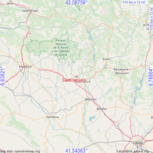
Castillazuelo GPS coordinates[2]
42° 4' 3.864" North, 0° 3' 53.676" East
| Map corner | latitude | longitude |
|---|---|---|
| Upper-left | 42.58756°, | -0.63821° |
| Center: | 42.06774°, | 0.06491° |
| Lower-right: | 41.54363°, | 0.76804° |
| Map W x H: | 116.1×116.1 km | = 72.1×72.1mi |
| max Lat: | 43.74134° ⇑24.3% North |
| Castillazuelo: | 42.06774° |
| min Lat: | ⇓75.7% South 27.64134° |
| min Long | Castillazuelo | max Long |
| -18.00367° | 0.06491° | 4.2899° |
| W 87.3%⇐ | ⇒12.7% E |
Elevation
Elevation of Castillazuelo is 368 m = 1207 ft, and this is 230 m = 755 ft below average elevation for this country.
| Max E: |
1682 m = 5518 ft | 71% |
| Avg. | 598 m = 1962 ft | |
| Castillazuelo | 368 m = 1207 ft | |
Min E: |
0 m = 0 ft | 29% |
See also: Spain elevation on elevation.city.
Geographical zone
Castillazuelo is located in North temperate zone (between Tropic of Cancer and the Arctic Circle). Distance of this Northern Tropic circle is 2071.6 km =1287.2 mi to South.| Distance of | km | miles | from Castillazuelo |
|---|---|---|---|
| North Pole | 5329.6 | 3311.7 | to North |
| Arctic Circle | 2723.7 | 1692.4 | to North |
| Tropic Cancer | 2071.6 | 1287.2 | to South |
| Equator | 4677.5 | 2906.5 | to South |


Nearby cities:
15 places around Castillazuelo: (largest is in red/bold)
• Abiego
12.5 km =7.8 mi,  298°
298°
• Adahuesca
10.6 km =6.6 mi,  325°
325°
• Alquézar
12.1 km =7.5 mi,  344°
344°
• Azara
7.8 km =4.8 mi,  272°
272°
• Azlor
9.6 km =6 mi,  287°
287°
• Barbastro
6.2 km =3.9 mi,  124°
124°
• Berbegal
13.3 km =8.3 mi,  205°
205°
• Colungo
11.5 km =7.1 mi,  1°
1°
• Ilche
12.3 km =7.6 mi,  182°
182°
• Laluenga
11.5 km =7.1 mi,  233°
233°
• Laperdiguera
12.6 km =7.8 mi, 227°
• Peraltilla
7 km =4.3 mi,  257°
257°
• Pozán de Vero
3.3 km =2.1 mi, 299°
• Salas Altas
5.2 km =3.2 mi, 3°
• Salas Bajas
3.9 km =2.4 mi,  22°
22°
Sources, notices
• [Note1] Compared only with cities in Spain existing in our database
• [Src1] Map data: © OpenStreetMap contributors (CC-BY-SA)
• [Src2] Other city data from geonames.org with taken over terms of usage.
• [Src3] Geographical zone / Annual Mean Temperature by Robert A. Rohde @ Wikipedia
