Bierge geodata
Bierge (Aragon) is a seat of a third-order administrative division; located in Spain in Europe/Madrid (GMT+2) time zone. With population of 247 people, there are 4760 cities with bigger population in this country. Compared to other cities in Spain, 78.2% of cities are located further ↓South; 86.5% of cities are located further ←West and 55.2% of cities have higher elevation than Bierge. Note1


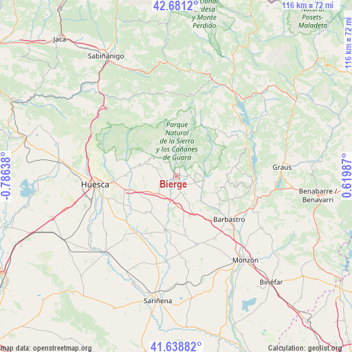
Bierge GPS coordinates[2]
42° 9' 43.776" North, 0° 4' 59.736" West
| Map corner | latitude | longitude |
|---|---|---|
| Upper-left | 42.6812°, | -0.78638° |
| Center: | 42.16216°, | -0.08326° |
| Lower-right: | 41.63882°, | 0.61987° |
| Map W x H: | 115.9×115.9 km | = 72×72mi |
| max Lat: | 43.74134° ⇑21.8% North |
| Bierge: | 42.16216° |
| min Lat: | ⇓78.2% South 27.64134° |
| min Long | Bierge | max Long |
| -18.00367° | -0.08326° | 4.2899° |
| W 86.5%⇐ | ⇒13.5% E |
Elevation
Elevation of Bierge is 593 m = 1946 ft, and this is 5 m = 16 ft below average elevation for this country.
| Max E: |
1682 m = 5518 ft | 55.2% |
| Avg. | 598 m = 1962 ft | |
| Bierge | 593 m = 1946 ft | |
Min E: |
0 m = 0 ft | 44.8% |
See also: Spain elevation on elevation.city.
Geographical zone
Bierge is located in North temperate zone (between Tropic of Cancer and the Arctic Circle). Distance of this Northern Tropic circle is 2082.1 km =1293.8 mi to South.| Distance of | km | miles | from Bierge |
|---|---|---|---|
| North Pole | 5319.1 | 3305.1 | to North |
| Arctic Circle | 2713.2 | 1685.9 | to North |
| Tropic Cancer | 2082.1 | 1293.8 | to South |
| Equator | 4688 | 2913 | to South |


Nearby cities:
15 places around Bierge: (largest is in red/bold)
• Abiego
4.7 km =2.9 mi,  165°
165°
• Adahuesca
6.5 km =4 mi,  106°
106°
• Alquézar
9.1 km =5.7 mi,  82°
82°
• Angüés
8.1 km =5 mi,  225°
225°
• Azara
11.1 km =6.9 mi,  156°
156°
• Azlor
8.2 km =5.1 mi, 157°
• Barbuñales
15.2 km =9.4 mi,  181°
181°
• Bárcabo
15.4 km =9.6 mi,  54°
54°
• Casbas de Huesca
4.7 km =2.9 mi,  260°
260°
• Colungo
12.5 km =7.8 mi,  85°
85°
• Ibieca
10.3 km =6.4 mi,  269°
269°
• Peraltilla
13.2 km =8.2 mi, 156°
• Pozán de Vero
12.9 km =8 mi,  133°
133°
• Salas Altas
13.6 km =8.5 mi, 113°
• Salas Bajas
15.4 km =9.6 mi,  116°
116°
Sources, notices
• [Note1] Compared only with cities in Spain existing in our database
• [Src1] Map data: © OpenStreetMap contributors (CC-BY-SA)
• [Src2] Other city data from geonames.org with taken over terms of usage.
• [Src3] Geographical zone / Annual Mean Temperature by Robert A. Rohde @ Wikipedia
