Ortuella geodata
Ortuella (Basque Country) is a populated place; located in Spain in Europe/Madrid (GMT+2) time zone. With population of 8,556 people, there are 908 cities with bigger population in this country. Compared to other cities in Spain, 97.7% of cities are located further ↓South; 53.5% of cities are located further ←West and 89.1% of cities have higher elevation than Ortuella. Note1


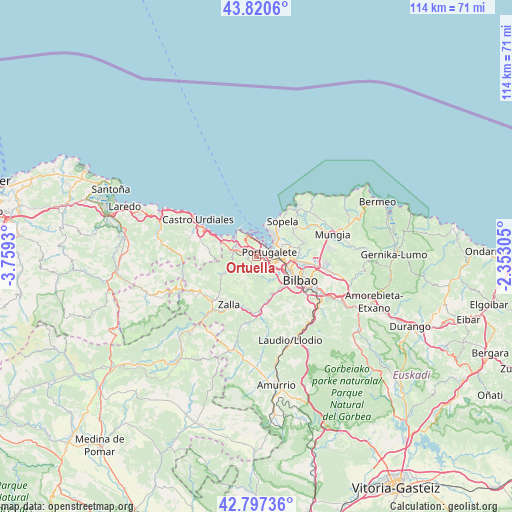
Ortuella GPS coordinates[2]
43° 18' 40.068" North, 3° 3' 22.212" West
| Map corner | latitude | longitude |
|---|---|---|
| Upper-left | 43.8206°, | -3.7593° |
| Center: | 43.31113°, | -3.05617° |
| Lower-right: | 42.79736°, | -2.35305° |
| Map W x H: | 113.8×113.8 km | = 70.7×70.7mi |
| max Lat: | 43.74134° ⇑2.3% North |
| Ortuella: | 43.31113° |
| min Lat: | ⇓97.7% South 27.64134° |
| min Long | Ortuella | max Long |
| -18.00367° | -3.05617° | 4.2899° |
| W 53.5%⇐ | ⇒46.5% E |
Elevation
Elevation of Ortuella is 80 m = 262 ft, and this is 518 m = 1699 ft below average elevation for this country.
| Max E: |
1682 m = 5518 ft | 89.1% |
| Avg. | 598 m = 1962 ft | |
| Ortuella | 80 m = 262 ft | |
Min E: |
0 m = 0 ft | 10.9% |
See also: Spain elevation on elevation.city.
Geographical zone
Ortuella is located in North temperate zone (between Tropic of Cancer and the Arctic Circle). Distance of this Northern Tropic circle is 2209.8 km =1373.1 mi to South.| Distance of | km | miles | from Ortuella |
|---|---|---|---|
| North Pole | 5191.3 | 3225.7 | to North |
| Arctic Circle | 2585.4 | 1606.5 | to North |
| Tropic Cancer | 2209.8 | 1373.1 | to South |
| Equator | 4815.7 | 2992.3 | to South |


Nearby cities:
15 places around Ortuella: (largest is in red/bold)
• Algorta
5.7 km =3.5 mi,  41°
41°
• Alonsotegi
9.2 km =5.7 mi,  143°
143°
• Barakaldo
5.7 km =3.5 mi,  106°
106°
• Berango
7.7 km =4.8 mi, 39°
• Erandio
6.7 km =4.2 mi,  96°
96°
• Erandiogoikoa
8.3 km =5.2 mi,  92°
92°
• Getxo
6.2 km =3.9 mi, 35°
• Leioa
5.7 km =3.5 mi,  72°
72°
• Portugalete
3.1 km =1.9 mi, 69°
• San Julián de Muskiz
4.3 km =2.7 mi,  304°
304°
• San Pedro Galdames
7.7 km =4.8 mi,  207°
207°
• Santurtzi
2.7 km =1.7 mi, 44°
• Sestao
4 km =2.5 mi, 92°
• Sopela
9.6 km =6 mi, 38°
• Zierbena
4.8 km =3 mi,  333°
333°
Sources, notices
• [Note1] Compared only with cities in Spain existing in our database
• [Src1] Map data: © OpenStreetMap contributors (CC-BY-SA)
• [Src2] Other city data from geonames.org with taken over terms of usage.
• [Src3] Geographical zone / Annual Mean Temperature by Robert A. Rohde @ Wikipedia
