Pollos geodata
Pollos (Castille and León) is a seat of a third-order administrative division; located in Spain in Europe/Madrid (GMT+2) time zone. With population of 781 people, there are 3249 cities with bigger population in this country. Compared to other cities in Spain, 59.3% of cities are located further ↓South; 74.1% of cities are located further →East and 51.6% of cities have lower elevation than Pollos. Note1
Administrative division(s):
- Level 1: Castille and León
- Level 2: Provincia de Valladolid
- Level 3: Pollos


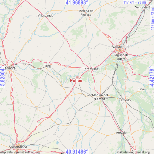
Pollos GPS coordinates[2]
41° 26' 38.616" North, 5° 7' 29.676" West
| Map corner | latitude | longitude |
|---|---|---|
| Upper-left | 41.96898°, | -5.82804° |
| Center: | 41.44406°, | -5.12491° |
| Lower-right: | 40.91486°, | -4.42179° |
| Map W x H: | 117.2×117.2 km | = 72.8×72.8mi |
| max Lat: | 43.74134° ⇑40.7% North |
| Pollos: | 41.44406° |
| min Lat: | ⇓59.3% South 27.64134° |
| min Long | Pollos | max Long |
| -18.00367° | -5.12491° | 4.2899° |
| W 25.9%⇐ | ⇒74.1% E |
Elevation
Elevation of Pollos is 676 m = 2218 ft, and this is 78 m = 256 ft above average elevation for this country.
| Max E: |
1682 m = 5518 ft | 48.4% |
| Pollos | 676 m 2218 ft | |
| Avg. | 598 m = 1962 ft | |
Min E: |
0 m = 0 ft | 51.6% |
See also: Spain elevation on elevation.city.
Geographical zone
Pollos is located in North temperate zone (between Tropic of Cancer and the Arctic Circle). Distance of this Northern Tropic circle is 2002.2 km =1244.1 mi to South.| Distance of | km | miles | from Pollos |
|---|---|---|---|
| North Pole | 5398.9 | 3354.7 | to North |
| Arctic Circle | 2793 | 1735.5 | to North |
| Tropic Cancer | 2002.2 | 1244.1 | to South |
| Equator | 4608.1 | 2863.3 | to South |


Nearby cities:
15 places around Pollos: (largest is in red/bold)
• Bercero
14.5 km =9 mi,  23°
23°
• Berceruelo
17 km =10.6 mi,  26°
26°
• Castronuño
13.1 km =8.1 mi,  242°
242°
• Marzales
15.9 km =9.9 mi,  357°
357°
• Nava del Rey
13.2 km =8.2 mi,  163°
163°
• Pedrosa del Rey
14.1 km =8.8 mi,  331°
331°
• Rueda
14.3 km =8.9 mi,  104°
104°
• San Román de Hornija
13.9 km =8.6 mi,  287°
287°
• Siete Iglesias de Trabancos
11.4 km =7.1 mi,  206°
206°
• Tordesillas
12.1 km =7.5 mi,  57°
57°
• Torrecilla de la Abadesa
5.5 km =3.4 mi, 34°
• Vega de Valdetronco
16.7 km =10.4 mi,  3°
3°
• Velilla
16.3 km =10.1 mi,  38°
38°
• Villafranca de Duero
14.8 km =9.2 mi,  265°
265°
• Villalar de los Comuneros
11.8 km =7.3 mi,  354°
354°
Sources, notices
• [Note1] Compared only with cities in Spain existing in our database
• [Src1] Map data: © OpenStreetMap contributors (CC-BY-SA)
• [Src2] Other city data from geonames.org with taken over terms of usage.
• [Src3] Geographical zone / Annual Mean Temperature by Robert A. Rohde @ Wikipedia
