Rueda geodata
Rueda (Castille and León) is a seat of a third-order administrative division; located in Spain in Europe/Madrid (GMT+2) time zone. With population of 1,476 people, there are 2481 cities with bigger population in this country. Compared to other cities in Spain, 58.1% of cities are located further ↓South; 71.9% of cities are located further →East and 57.9% of cities have lower elevation than Rueda. Note1
Administrative division(s):
- Level 1: Castille and León
- Level 2: Provincia de Valladolid
- Level 3: Rueda


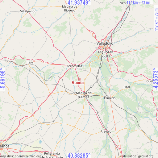
Rueda GPS coordinates[2]
41° 24' 44.316" North, 4° 57' 31.86" West
| Map corner | latitude | longitude |
|---|---|---|
| Upper-left | 41.93749°, | -5.66198° |
| Center: | 41.41231°, | -4.95885° |
| Lower-right: | 40.88285°, | -4.25573° |
| Map W x H: | 117.3×117.3 km | = 72.9×72.9mi |
| max Lat: | 43.74134° ⇑41.9% North |
| Rueda: | 41.41231° |
| min Lat: | ⇓58.1% South 27.64134° |
| min Long | Rueda | max Long |
| -18.00367° | -4.95885° | 4.2899° |
| W 28.1%⇐ | ⇒71.9% E |
Elevation
Elevation of Rueda is 729 m = 2392 ft, and this is 131 m = 430 ft above average elevation for this country.
| Max E: |
1682 m = 5518 ft | 42.1% |
| Rueda | 729 m 2392 ft | |
| Avg. | 598 m = 1962 ft | |
Min E: |
0 m = 0 ft | 57.9% |
See also: Spain elevation on elevation.city.
Geographical zone
Rueda is located in North temperate zone (between Tropic of Cancer and the Arctic Circle). Distance of this Northern Tropic circle is 1998.7 km =1241.9 mi to South.| Distance of | km | miles | from Rueda |
|---|---|---|---|
| North Pole | 5402.4 | 3356.9 | to North |
| Arctic Circle | 2796.6 | 1737.7 | to North |
| Tropic Cancer | 1998.7 | 1241.9 | to South |
| Equator | 4604.6 | 2861.2 | to South |


Nearby cities:
15 places around Rueda: (largest is in red/bold)
• La Seca
4.4 km =2.7 mi,  88°
88°
• Matapozuelos
14 km =8.7 mi, 89°
• Matilla de los Caños
15.1 km =9.4 mi,  357°
357°
• Medina del Campo
11.7 km =7.3 mi,  161°
161°
• Nava del Rey
13.7 km =8.5 mi,  228°
228°
• Pollos
14.3 km =8.9 mi,  284°
284°
• Pozal de Gallinas
14.4 km =8.9 mi,  136°
136°
• San Miguel del Pino
11.5 km =7.1 mi,  20°
20°
• Serrada
9.4 km =5.8 mi,  58°
58°
• Tordesillas
10.6 km =6.6 mi,  340°
340°
• Torrecilla de la Abadesa
13.4 km =8.3 mi,  306°
306°
• Velilla
16.8 km =10.4 mi,  346°
346°
• Ventosa de la Cuesta
10.8 km =6.7 mi, 90°
• Villanueva de Duero
14.2 km =8.8 mi,  32°
32°
• Villaverde de Medina
13 km =8.1 mi,  205°
205°
Sources, notices
• [Note1] Compared only with cities in Spain existing in our database
• [Src1] Map data: © OpenStreetMap contributors (CC-BY-SA)
• [Src2] Other city data from geonames.org with taken over terms of usage.
• [Src3] Geographical zone / Annual Mean Temperature by Robert A. Rohde @ Wikipedia
