Herriko Plaza geodata
Herriko Plaza (Basque Country) is a populated place; located in Spain in Europe/Madrid (GMT+2) time zone. With population of 686 people, there are 3423 cities with bigger population in this country. Compared to other cities in Spain, 95.6% of cities are located further ↓South; 57.7% of cities are located further ←West and 85.9% of cities have higher elevation than Herriko Plaza. Note1


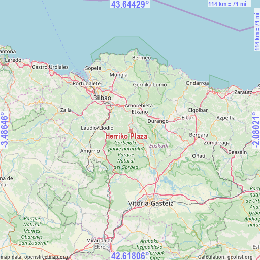
Herriko Plaza GPS coordinates[2]
43° 7' 59.988" North, 2° 46' 59.988" West
| Map corner | latitude | longitude |
|---|---|---|
| Upper-left | 43.64429°, | -3.48646° |
| Center: | 43.13333°, | -2.78333° |
| Lower-right: | 42.61806°, | -2.08021° |
| Map W x H: | 114.1×114.1 km | = 70.9×70.9mi |
| max Lat: | 43.74134° ⇑4.4% North |
| Herriko Plaza: | 43.13333° |
| min Lat: | ⇓95.6% South 27.64134° |
| min Long | Herriko Plaza | max Long |
| -18.00367° | -2.78333° | 4.2899° |
| W 57.7%⇐ | ⇒42.3% E |
Elevation
Elevation of Herriko Plaza is 126 m = 413 ft, and this is 472 m = 1549 ft below average elevation for this country.
| Max E: |
1682 m = 5518 ft | 85.9% |
| Avg. | 598 m = 1962 ft | |
| Herriko Plaza | 126 m = 413 ft | |
Min E: |
0 m = 0 ft | 14.1% |
See also: Spain elevation on elevation.city.
Geographical zone
Herriko Plaza is located in North temperate zone (between Tropic of Cancer and the Arctic Circle). Distance of this Northern Tropic circle is 2190.1 km =1360.9 mi to South.| Distance of | km | miles | from Herriko Plaza |
|---|---|---|---|
| North Pole | 5211.1 | 3238 | to North |
| Arctic Circle | 2605.2 | 1618.8 | to North |
| Tropic Cancer | 2190.1 | 1360.9 | to South |
| Equator | 4796 | 2980.1 | to South |


Nearby cities:
15 places around Herriko Plaza: (largest is in red/bold)
• Abadiño
14.2 km =8.8 mi,  82°
82°
• Amorebieta
10.1 km =6.3 mi,  23°
23°
• Areatza
2.3 km =1.4 mi,  143°
143°
• Arrigorriaga
11.9 km =7.4 mi,  315°
315°
• Basauri
14.5 km =9 mi, 324°
• Durango
12.8 km =8 mi,  70°
70°
• Elexalde
12.3 km =7.6 mi,  278°
278°
• Galdakao
11.9 km =7.4 mi,  335°
335°
• Iurreta
13.4 km =8.3 mi, 65°
• Izurtza
12.3 km =7.6 mi, 81°
• Laudio / Llodio
14.5 km =9 mi,  274°
274°
• Mañaria
9.9 km =6.2 mi,  86°
86°
• Ubide
14.4 km =8.9 mi,  147°
147°
• Zaratamo
11.5 km =7.1 mi, 323°
• Zeanuri
4.6 km =2.9 mi, 143°
Sources, notices
• [Note1] Compared only with cities in Spain existing in our database
• [Src1] Map data: © OpenStreetMap contributors (CC-BY-SA)
• [Src2] Other city data from geonames.org with taken over terms of usage.
• [Src3] Geographical zone / Annual Mean Temperature by Robert A. Rohde @ Wikipedia
