Abadiño geodata
Abadiño (Basque Country) is a seat of a third-order administrative division; located in Spain in Europe/Madrid (GMT+2) time zone. In our database, there are 6762 cities with bigger population. Compared to other cities in Spain, 95.9% of cities are located further ↓South; 59.8% of cities are located further ←West and 85% of cities have higher elevation than Abadiño. Note1


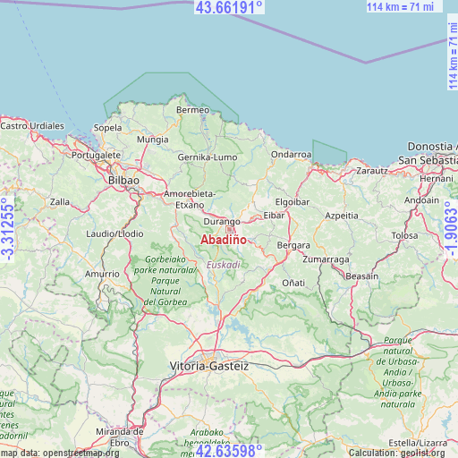
Abadiño GPS coordinates[2]
43° 9' 3.96" North, 2° 36' 33.912" West
| Map corner | latitude | longitude |
|---|---|---|
| Upper-left | 43.66191°, | -3.31255° |
| Center: | 43.1511°, | -2.60942° |
| Lower-right: | 42.63598°, | -1.9063° |
| Map W x H: | 114.1×114.1 km | = 70.9×70.9mi |
| max Lat: | 43.74134° ⇑4.1% North |
| Abadiño: | 43.1511° |
| min Lat: | ⇓95.9% South 27.64134° |
| min Long | Abadiño | max Long |
| -18.00367° | -2.60942° | 4.2899° |
| W 59.8%⇐ | ⇒40.2% E |
Elevation
Elevation of Abadiño is 137 m = 449 ft, and this is 461 m = 1512 ft below average elevation for this country.
| Max E: |
1682 m = 5518 ft | 85% |
| Avg. | 598 m = 1962 ft | |
| Abadiño | 137 m = 449 ft | |
Min E: |
0 m = 0 ft | 15% |
See also: Spain elevation on elevation.city.
Geographical zone
Abadiño is located in North temperate zone (between Tropic of Cancer and the Arctic Circle). Distance of this Northern Tropic circle is 2192 km =1362 mi to South.| Distance of | km | miles | from Abadiño |
|---|---|---|---|
| North Pole | 5209.1 | 3236.8 | to North |
| Arctic Circle | 2603.2 | 1617.6 | to North |
| Tropic Cancer | 2192 | 1362 | to South |
| Equator | 4798 | 2981.3 | to South |


Nearby cities:
15 places around Abadiño: (largest is in red/bold)
• Amorebieta
12.4 km =7.7 mi,  305°
305°
• Areatza
13.3 km =8.3 mi,  253°
253°
• Arrasate / Mondragón
13.7 km =8.5 mi,  134°
134°
• Berriz
3.9 km =2.4 mi,  63°
63°
• Durango
3 km =1.9 mi,  318°
318°
• Eibar
11.8 km =7.3 mi,  71°
71°
• Elgeta
9.9 km =6.2 mi,  99°
99°
• Elorrio
6.1 km =3.8 mi,  113°
113°
• Ermua
9.5 km =5.9 mi, 65°
• Iurreta
4.1 km =2.5 mi,  331°
331°
• Izurtza
1.9 km =1.2 mi,  266°
266°
• Mañaria
4.4 km =2.7 mi, 251°
• Otxandio
13.5 km =8.4 mi,  194°
194°
• Zaldibar
6.4 km =4 mi, 74°
• Zeanuri
12.7 km =7.9 mi,  243°
243°
Sources, notices
• [Note1] Compared only with cities in Spain existing in our database
• [Src1] Map data: © OpenStreetMap contributors (CC-BY-SA)
• [Src2] Other city data from geonames.org with taken over terms of usage.
• [Src3] Geographical zone / Annual Mean Temperature by Robert A. Rohde @ Wikipedia
