Pinilla de Molina geodata
Pinilla de Molina (Castille-La Mancha) is a seat of a third-order administrative division; located in Spain in Europe/Madrid (GMT+2) time zone. With population of 26 people, there are 6687 cities with bigger population in this country. Compared to other cities in Spain, 58.3% of cities are located further ↑North; 68.7% of cities are located further ←West and 97.3% of cities have lower elevation than Pinilla de Molina. Note1
Administrative division(s):
- Level 1: Castille-La Mancha
- Level 2: Provincia de Guadalajara
- Level 3: Pinilla de Molina


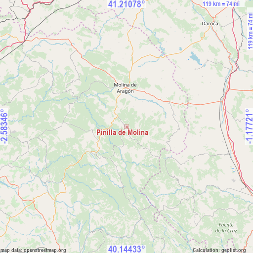
Pinilla de Molina GPS coordinates[2]
40° 40' 46.884" North, 1° 52' 49.224" West
| Map corner | latitude | longitude |
|---|---|---|
| Upper-left | 41.21078°, | -2.58346° |
| Center: | 40.67969°, | -1.88034° |
| Lower-right: | 40.14433°, | -1.17721° |
| Map W x H: | 118.6×118.6 km | = 73.7×73.7mi |
| max Lat: | 43.74134° ⇑58.3% North |
| Pinilla de Molina: | 40.67969° |
| min Lat: | ⇓41.7% South 27.64134° |
| min Long | Pinilla de Moli | max Long |
| -18.00367° | -1.88034° | 4.2899° |
| W 68.7%⇐ | ⇒31.3% E |
Elevation
Elevation of Pinilla de Molina is 1220 m = 4003 ft, and this is 622 m = 2041 ft above average elevation for this country.
| Max E: |
1682 m = 5518 ft | 2.7% |
| Pinilla de Molina | 1220 m 4003 ft | |
| Avg. | 598 m = 1962 ft | |
Min E: |
0 m = 0 ft | 97.3% |
See also: Spain elevation on elevation.city.
Geographical zone
Pinilla de Molina is located in North temperate zone (between Tropic of Cancer and the Arctic Circle). Distance of this Northern Tropic circle is 1917.2 km =1191.3 mi to South.| Distance of | km | miles | from Pinilla de Molina |
|---|---|---|---|
| North Pole | 5483.9 | 3407.5 | to North |
| Arctic Circle | 2878 | 1788.3 | to North |
| Tropic Cancer | 1917.2 | 1191.3 | to South |
| Equator | 4523.2 | 2810.6 | to South |


Nearby cities:
15 places around Pinilla de Molina: (largest is in red/bold)
• Alcoroches
12.8 km =8 mi,  117°
117°
• Baños de Tajo
8.4 km =5.2 mi,  299°
299°
• Checa
12.9 km =8 mi,  143°
143°
• Chequilla
9.3 km =5.8 mi,  151°
151°
• Fuembellida
13.1 km =8.1 mi,  310°
310°
• Megina
4.6 km =2.9 mi,  169°
169°
• Peralejos de las Truchas
9.9 km =6.2 mi,  194°
194°
• Piqueras
13.5 km =8.4 mi,  97°
97°
• Poveda de la Sierra
13.2 km =8.2 mi,  252°
252°
• Taravilla
7.7 km =4.8 mi,  284°
284°
• Terzaga
2.6 km =1.6 mi, 310°
• Tierzo
8.8 km =5.5 mi,  331°
331°
• Torrecuadrada de Molina
9.9 km =6.2 mi,  38°
38°
• Torremochuela
10.1 km =6.3 mi,  18°
18°
• Valhermoso
13.6 km =8.5 mi, 330°
Sources, notices
• [Note1] Compared only with cities in Spain existing in our database
• [Src1] Map data: © OpenStreetMap contributors (CC-BY-SA)
• [Src2] Other city data from geonames.org with taken over terms of usage.
• [Src3] Geographical zone / Annual Mean Temperature by Robert A. Rohde @ Wikipedia
